You are here: Home > Network List > US - United States National Seismic Network Stations List
> Station GLMI Grayling, Michigan, USA > Earthquake Result Viewer
GLMI Grayling, Michigan, USA - Earthquake Result Viewer
| Earthquake location: |
Andreanof Islands, Aleutian Is. |
| Earthquake latitude/longitude: |
51.2/-175.6 |
| Earthquake time(UTC): |
2019/11/24 (328) 00:54:03 GMT |
| Earthquake Depth: |
34 km |
| Earthquake Magnitude: |
5.6 Mi |
| Earthquake Catalog/Contributor: |
NEIC PDE/at |
|
| Network: |
US United States National Seismic Network |
| Station: |
GLMI Grayling, Michigan, USA |
| Lat/Lon: |
44.82 N/84.62 W |
| Elevation: |
387 m |
|
| Distance: |
57.4 deg |
| Az: |
57.609 deg |
| Baz: |
311.696 deg |
| Ray Param: |
0.063443094 |
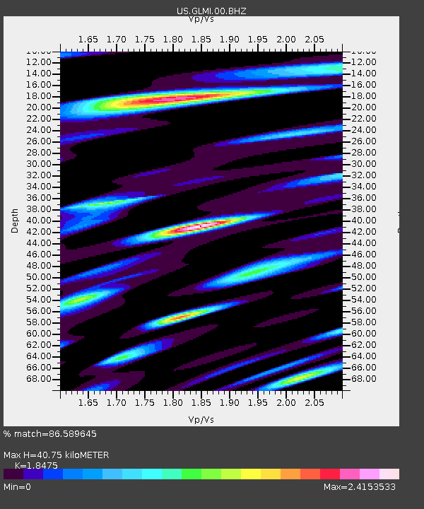
| Estimated Moho Depth: |
40.75 km |
| Estimated Crust Vp/Vs: |
1.85 |
| Assumed Crust Vp: |
6.483 km/s |
| Estimated Crust Vs: |
3.509 km/s |
| Estimated Crust Poisson's Ratio: |
0.29 |
|
| Radial Match: |
86.589645 % |
| Radial Bump: |
400 |
| Transverse Match: |
68.457634 % |
| Transverse Bump: |
400 |
| SOD ConfigId: |
19951751 |
| Insert Time: |
2019-12-08 01:11:38.658 +0000 |
| GWidth: |
2.5 |
| Max Bumps: |
400 |
| Tol: |
0.001 |
|

Signal To Noise
| Channel | StoN | STA | LTA |
| US:GLMI:00:BHZ:20191124T01:03:17.575012Z | 8.695363 | 3.7067805E-6 | 4.2629395E-7 |
| US:GLMI:00:BH1:20191124T01:03:17.575012Z | 3.53865 | 1.6592413E-6 | 4.6889105E-7 |
| US:GLMI:00:BH2:20191124T01:03:17.575012Z | 4.0641317 | 2.6897608E-6 | 6.618292E-7 |
| Arrivals |
| Ps | 5.6 SECOND |
| PpPs | 17 SECOND |
| PsPs/PpSs | 23 SECOND |


