You are here: Home > Network List > UU - University of Utah Regional Network Stations List
> Station PKCU Pink Cliffs, UT, USA > Earthquake Result Viewer
PKCU Pink Cliffs, UT, USA - Earthquake Result Viewer
| Earthquake location: |
Andreanof Islands, Aleutian Is. |
| Earthquake latitude/longitude: |
51.2/-175.6 |
| Earthquake time(UTC): |
2019/11/24 (328) 00:54:03 GMT |
| Earthquake Depth: |
34 km |
| Earthquake Magnitude: |
5.6 Mi |
| Earthquake Catalog/Contributor: |
NEIC PDE/at |
|
| Network: |
UU University of Utah Regional Network |
| Station: |
PKCU Pink Cliffs, UT, USA |
| Lat/Lon: |
37.44 N/112.31 W |
| Elevation: |
2834 m |
|
| Distance: |
45.9 deg |
| Az: |
81.776 deg |
| Baz: |
308.511 deg |
| Ray Param: |
0.070905365 |
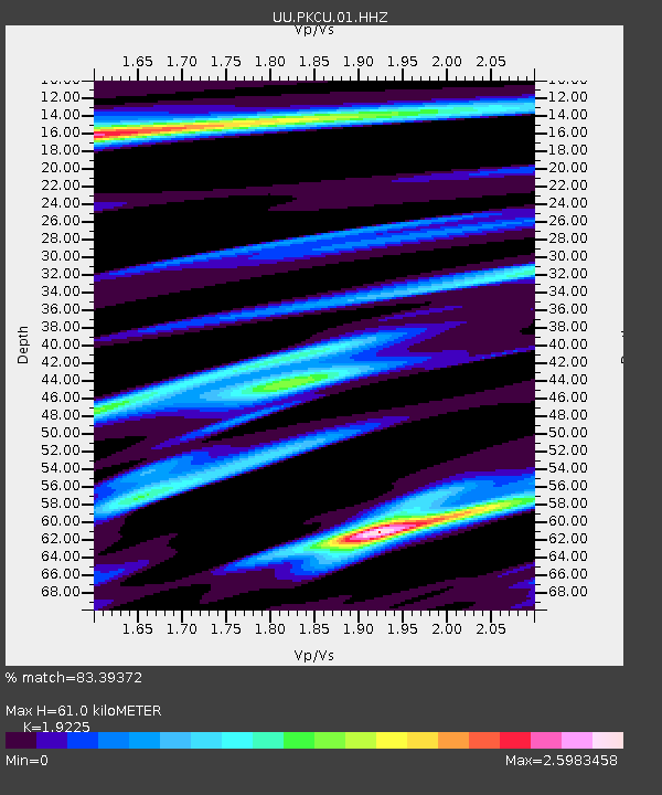
| Estimated Moho Depth: |
61.0 km |
| Estimated Crust Vp/Vs: |
1.92 |
| Assumed Crust Vp: |
6.194 km/s |
| Estimated Crust Vs: |
3.222 km/s |
| Estimated Crust Poisson's Ratio: |
0.31 |
|
| Radial Match: |
83.39372 % |
| Radial Bump: |
346 |
| Transverse Match: |
63.946716 % |
| Transverse Bump: |
345 |
| SOD ConfigId: |
19951751 |
| Insert Time: |
2019-12-08 01:12:09.337 +0000 |
| GWidth: |
2.5 |
| Max Bumps: |
400 |
| Tol: |
0.001 |
|

Signal To Noise
| Channel | StoN | STA | LTA |
| UU:PKCU:01:HHZ:20191124T01:01:51.799988Z | 3.480278 | 3.7565073E-8 | 1.0793699E-8 |
| UU:PKCU:01:HHN:20191124T01:01:51.799988Z | 1.897273 | 3.157564E-8 | 1.6642646E-8 |
| UU:PKCU:01:HHE:20191124T01:01:51.799988Z | 0.8134906 | 1.4915635E-8 | 1.833535E-8 |
| Arrivals |
| Ps | 9.6 SECOND |
| PpPs | 27 SECOND |
| PsPs/PpSs | 37 SECOND |


