You are here: Home > Network List > UU - University of Utah Regional Network Stations List
> Station TMU Trail Mountain (BB), UT, USA > Earthquake Result Viewer
TMU Trail Mountain (BB), UT, USA - Earthquake Result Viewer
| Earthquake location: |
Andreanof Islands, Aleutian Is. |
| Earthquake latitude/longitude: |
51.2/-175.6 |
| Earthquake time(UTC): |
2019/11/24 (328) 00:54:03 GMT |
| Earthquake Depth: |
34 km |
| Earthquake Magnitude: |
5.6 Mi |
| Earthquake Catalog/Contributor: |
NEIC PDE/at |
|
| Network: |
UU University of Utah Regional Network |
| Station: |
TMU Trail Mountain (BB), UT, USA |
| Lat/Lon: |
39.30 N/111.21 W |
| Elevation: |
2731 m |
|
| Distance: |
45.5 deg |
| Az: |
78.992 deg |
| Baz: |
307.247 deg |
| Ray Param: |
0.07119388 |
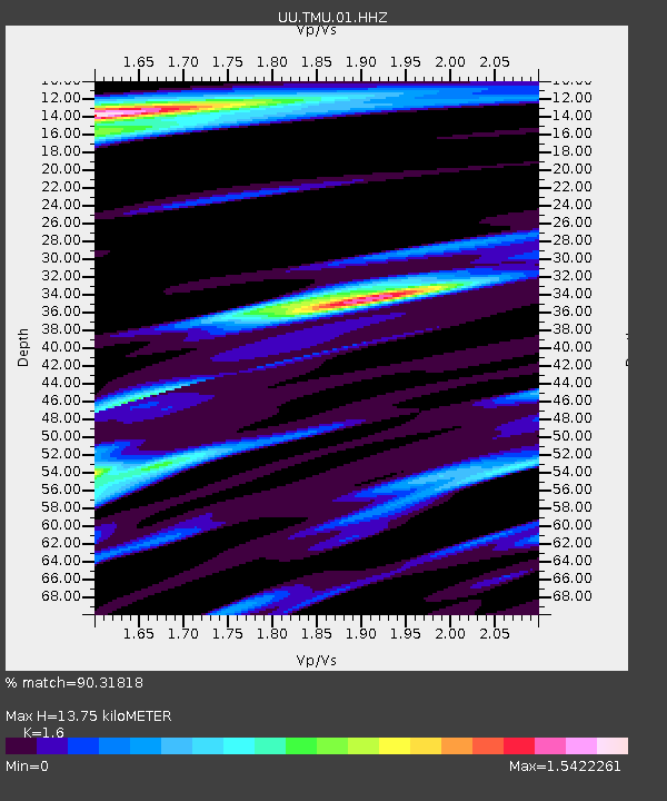
| Estimated Moho Depth: |
13.75 km |
| Estimated Crust Vp/Vs: |
1.60 |
| Assumed Crust Vp: |
6.207 km/s |
| Estimated Crust Vs: |
3.879 km/s |
| Estimated Crust Poisson's Ratio: |
0.18 |
|
| Radial Match: |
90.31818 % |
| Radial Bump: |
400 |
| Transverse Match: |
81.87615 % |
| Transverse Bump: |
400 |
| SOD ConfigId: |
19951751 |
| Insert Time: |
2019-12-08 01:12:15.849 +0000 |
| GWidth: |
2.5 |
| Max Bumps: |
400 |
| Tol: |
0.001 |
|

Signal To Noise
| Channel | StoN | STA | LTA |
| UU:TMU:01:HHZ:20191124T01:01:48.230011Z | 5.99638 | 4.0080913E-8 | 6.6841848E-9 |
| UU:TMU:01:HHN:20191124T01:01:48.230011Z | 2.7045968 | 1.2813955E-8 | 4.737843E-9 |
| UU:TMU:01:HHE:20191124T01:01:48.230011Z | 3.5527174 | 2.4675796E-8 | 6.9456116E-9 |
| Arrivals |
| Ps | 1.4 SECOND |
| PpPs | 5.4 SECOND |
| PsPs/PpSs | 6.8 SECOND |


