You are here: Home > Network List > TA - USArray Transportable Network (new EarthScope stations) Stations List
> Station D27A Center, ND, USA > Earthquake Result Viewer
D27A Center, ND, USA - Earthquake Result Viewer
| Earthquake location: |
Samoa Islands Region |
| Earthquake latitude/longitude: |
-15.2/-172.6 |
| Earthquake time(UTC): |
2009/08/30 (242) 14:51:32 GMT |
| Earthquake Depth: |
11 km |
| Earthquake Magnitude: |
6.4 MB, 6.3 MS, 6.6 MW, 6.6 MW |
| Earthquake Catalog/Contributor: |
WHDF/NEIC |
|
| Network: |
TA USArray Transportable Network (new EarthScope stations) |
| Station: |
D27A Center, ND, USA |
| Lat/Lon: |
47.11 N/101.53 W |
| Elevation: |
685 m |
|
| Distance: |
88.6 deg |
| Az: |
40.256 deg |
| Baz: |
245.961 deg |
| Ray Param: |
0.042428948 |
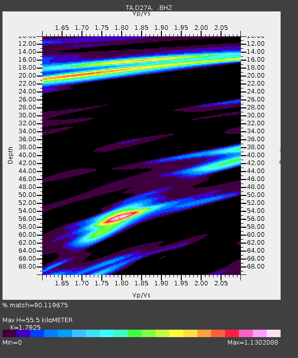
| Estimated Moho Depth: |
55.5 km |
| Estimated Crust Vp/Vs: |
1.79 |
| Assumed Crust Vp: |
6.438 km/s |
| Estimated Crust Vs: |
3.591 km/s |
| Estimated Crust Poisson's Ratio: |
0.27 |
|
| Radial Match: |
90.119675 % |
| Radial Bump: |
303 |
| Transverse Match: |
78.65219 % |
| Transverse Bump: |
316 |
| SOD ConfigId: |
2622 |
| Insert Time: |
2010-03-07 06:13:55.235 +0000 |
| GWidth: |
2.5 |
| Max Bumps: |
400 |
| Tol: |
0.001 |
|
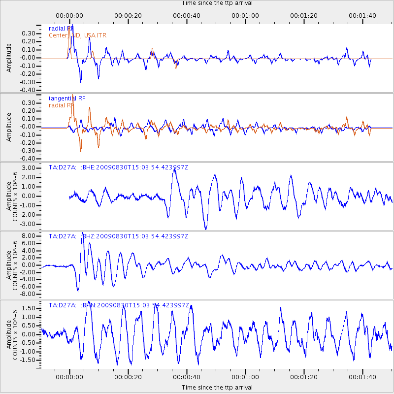
Signal To Noise
| Channel | StoN | STA | LTA |
| TA:D27A: :BHZ:20090830T15:03:54.423997Z | 24.488808 | 4.2439674E-6 | 1.7330233E-7 |
| TA:D27A: :BHN:20090830T15:03:54.423997Z | 1.88916 | 6.130775E-7 | 3.2452382E-7 |
| TA:D27A: :BHE:20090830T15:03:54.423997Z | 2.2547512 | 8.7447336E-7 | 3.8783583E-7 |
| Arrivals |
| Ps | 7.0 SECOND |
| PpPs | 24 SECOND |
| PsPs/PpSs | 31 SECOND |


