You are here: Home > Network List > TA - USArray Transportable Network (new EarthScope stations) Stations List
> Station D27A Center, ND, USA > Earthquake Result Viewer
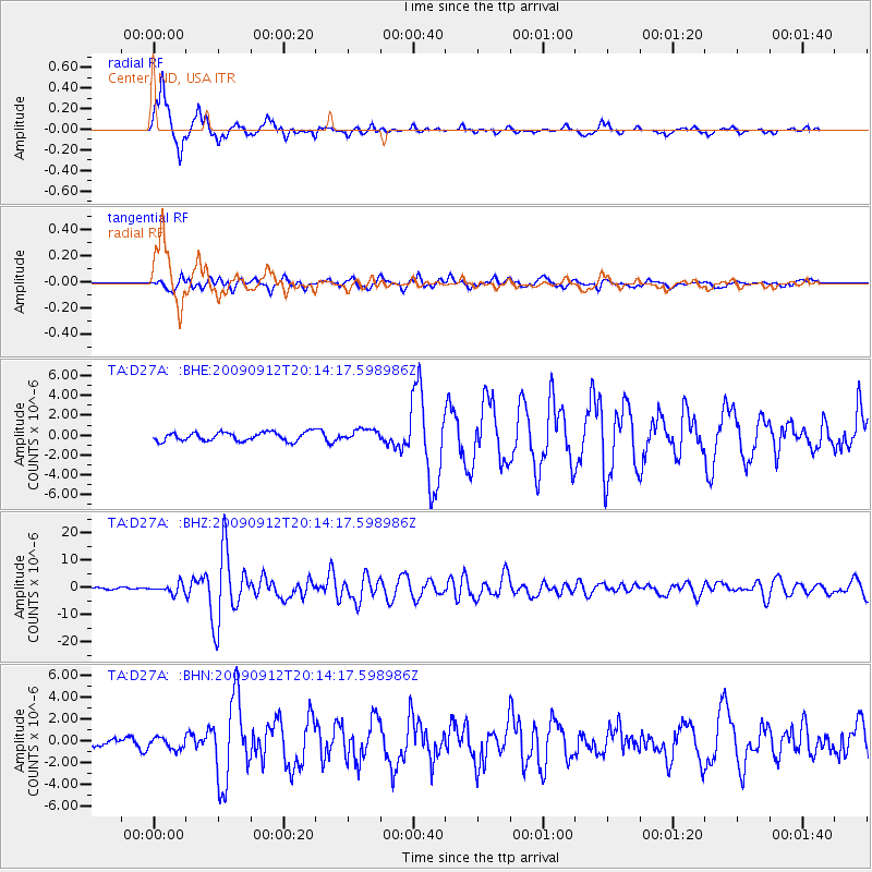
D27A Center, ND, USA - Earthquake Result Viewer
*The percent match for this event was below the threshold and hence no stack was calculated.
| Earthquake location: |
Near Coast Of Venezuela |
| Earthquake latitude/longitude: |
10.7/-67.9 |
| Earthquake time(UTC): |
2009/09/12 (255) 20:06:24 GMT |
| Earthquake Depth: |
10 km |
| Earthquake Magnitude: |
6.3 MB, 6.4 MS, 6.3 MW, 6.3 MW |
| Earthquake Catalog/Contributor: |
WHDF/NEIC |
|
| Network: |
TA USArray Transportable Network (new EarthScope stations) |
| Station: |
D27A Center, ND, USA |
| Lat/Lon: |
47.11 N/101.53 W |
| Elevation: |
685 m |
|
| Distance: |
46.1 deg |
| Az: |
328.329 deg |
| Baz: |
130.935 deg |
| Ray Param: |
$rayparam |
*The percent match for this event was below the threshold and hence was not used in the summary stack. |
|
| Radial Match: |
95.49666 % |
| Radial Bump: |
318 |
| Transverse Match: |
76.7804 % |
| Transverse Bump: |
400 |
| SOD ConfigId: |
2622 |
| Insert Time: |
2010-03-07 06:14:04.996 +0000 |
| GWidth: |
2.5 |
| Max Bumps: |
400 |
| Tol: |
0.001 |
|
Signal To Noise
| Channel | StoN | STA | LTA |
| TA:D27A: :BHZ:20090912T20:14:17.598986Z | 6.204708 | 1.6809985E-6 | 2.7092307E-7 |
| TA:D27A: :BHN:20090912T20:14:17.598986Z | 1.6073333 | 5.2886764E-7 | 3.290342E-7 |
| TA:D27A: :BHE:20090912T20:14:17.598986Z | 1.3651813 | 6.000332E-7 | 4.3952642E-7 |
| Arrivals |
| Ps | |
| PpPs | |
| PsPs/PpSs | |


