You are here: Home > Network List > TA - USArray Transportable Network (new EarthScope stations) Stations List
> Station D27A Center, ND, USA > Earthquake Result Viewer
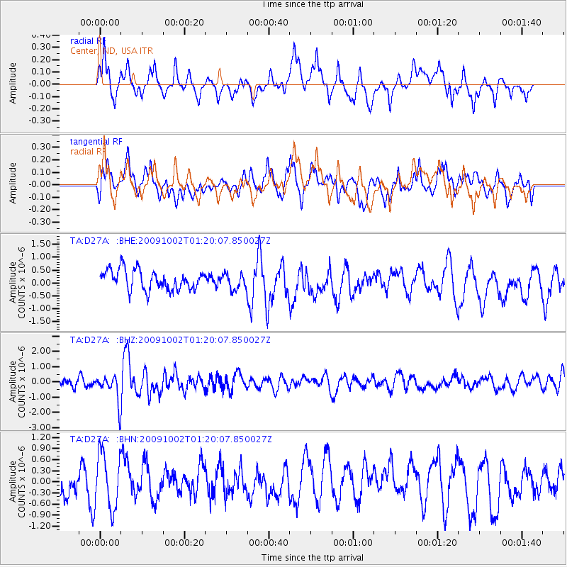
D27A Center, ND, USA - Earthquake Result Viewer
*The percent match for this event was below the threshold and hence no stack was calculated.
| Earthquake location: |
Tonga Islands |
| Earthquake latitude/longitude: |
-16.3/-173.5 |
| Earthquake time(UTC): |
2009/10/02 (275) 01:07:39 GMT |
| Earthquake Depth: |
8.0 km |
| Earthquake Magnitude: |
6.1 MB, 6.0 MS, 6.1 MW, 6.1 MW |
| Earthquake Catalog/Contributor: |
WHDF/NEIC |
|
| Network: |
TA USArray Transportable Network (new EarthScope stations) |
| Station: |
D27A Center, ND, USA |
| Lat/Lon: |
47.11 N/101.53 W |
| Elevation: |
685 m |
|
| Distance: |
90.1 deg |
| Az: |
40.499 deg |
| Baz: |
245.904 deg |
| Ray Param: |
$rayparam |
*The percent match for this event was below the threshold and hence was not used in the summary stack. |
|
| Radial Match: |
64.73378 % |
| Radial Bump: |
400 |
| Transverse Match: |
48.428493 % |
| Transverse Bump: |
400 |
| SOD ConfigId: |
2622 |
| Insert Time: |
2010-03-07 06:14:10.031 +0000 |
| GWidth: |
2.5 |
| Max Bumps: |
400 |
| Tol: |
0.001 |
|
Signal To Noise
| Channel | StoN | STA | LTA |
| TA:D27A: :BHZ:20091002T01:20:07.850027Z | 3.114037 | 9.1373187E-7 | 2.9342357E-7 |
| TA:D27A: :BHN:20091002T01:20:07.850027Z | 1.0983233 | 7.5653156E-7 | 6.8880587E-7 |
| TA:D27A: :BHE:20091002T01:20:07.850027Z | 0.8147304 | 3.131563E-7 | 3.84368E-7 |
| Arrivals |
| Ps | |
| PpPs | |
| PsPs/PpSs | |


