You are here: Home > Network List > TA - USArray Transportable Network (new EarthScope stations) Stations List
> Station D26A Manning, ND, USA > Earthquake Result Viewer
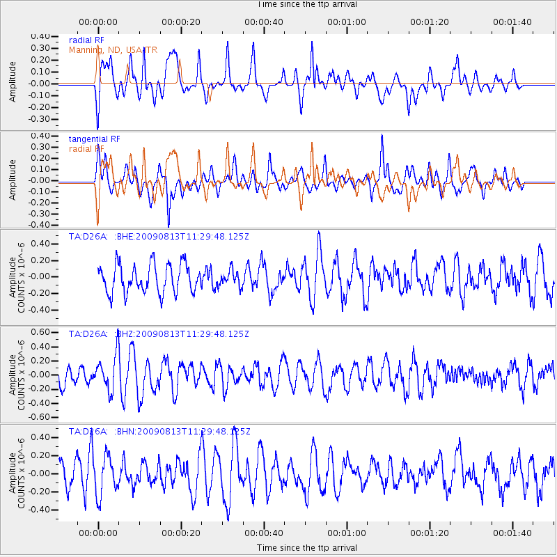
D26A Manning, ND, USA - Earthquake Result Viewer
*The percent match for this event was below the threshold and hence no stack was calculated.
| Earthquake location: |
Tonga Islands |
| Earthquake latitude/longitude: |
-21.7/-174.6 |
| Earthquake time(UTC): |
2009/08/13 (225) 11:17:01 GMT |
| Earthquake Depth: |
10 km |
| Earthquake Magnitude: |
5.6 MW, 5.3 MB |
| Earthquake Catalog/Contributor: |
WHDF/NEIC |
|
| Network: |
TA USArray Transportable Network (new EarthScope stations) |
| Station: |
D26A Manning, ND, USA |
| Lat/Lon: |
47.03 N/102.44 W |
| Elevation: |
693 m |
|
| Distance: |
94.2 deg |
| Az: |
40.751 deg |
| Baz: |
242.582 deg |
| Ray Param: |
$rayparam |
*The percent match for this event was below the threshold and hence was not used in the summary stack. |
|
| Radial Match: |
53.98731 % |
| Radial Bump: |
400 |
| Transverse Match: |
54.943302 % |
| Transverse Bump: |
400 |
| SOD ConfigId: |
2622 |
| Insert Time: |
2010-03-07 06:14:27.309 +0000 |
| GWidth: |
2.5 |
| Max Bumps: |
400 |
| Tol: |
0.001 |
|
Signal To Noise
| Channel | StoN | STA | LTA |
| TA:D26A: :BHZ:20090813T11:29:48.125Z | 2.1801732 | 2.5722855E-7 | 1.17985365E-7 |
| TA:D26A: :BHN:20090813T11:29:48.125Z | 1.0367763 | 2.1365624E-7 | 2.0607749E-7 |
| TA:D26A: :BHE:20090813T11:29:48.125Z | 0.5694238 | 9.7336304E-8 | 1.7093825E-7 |
| Arrivals |
| Ps | |
| PpPs | |
| PsPs/PpSs | |


