You are here: Home > Network List > TA - USArray Transportable Network (new EarthScope stations) Stations List
> Station D26A Manning, ND, USA > Earthquake Result Viewer
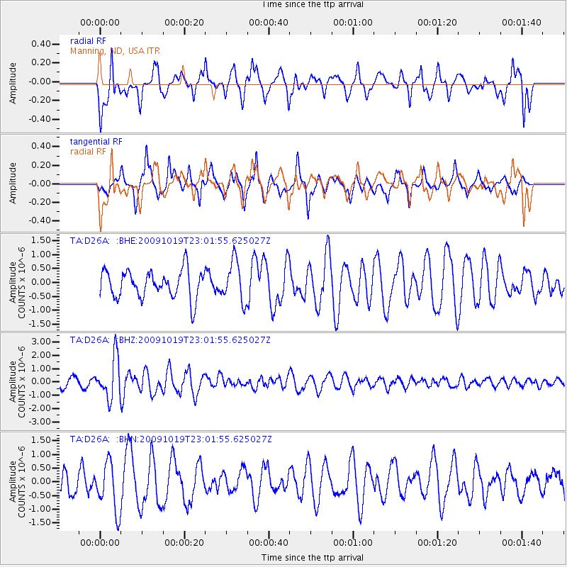
D26A Manning, ND, USA - Earthquake Result Viewer
*The percent match for this event was below the threshold and hence no stack was calculated.
| Earthquake location: |
Samoa Islands Region |
| Earthquake latitude/longitude: |
-15.4/-172.3 |
| Earthquake time(UTC): |
2009/10/19 (292) 22:49:38 GMT |
| Earthquake Depth: |
18 km |
| Earthquake Magnitude: |
6.2 MB, 5.7 MS, 6.0 MW, 5.9 MW |
| Earthquake Catalog/Contributor: |
WHDF/NEIC |
|
| Network: |
TA USArray Transportable Network (new EarthScope stations) |
| Station: |
D26A Manning, ND, USA |
| Lat/Lon: |
47.03 N/102.44 W |
| Elevation: |
693 m |
|
| Distance: |
88.0 deg |
| Az: |
39.979 deg |
| Baz: |
244.976 deg |
| Ray Param: |
$rayparam |
*The percent match for this event was below the threshold and hence was not used in the summary stack. |
|
| Radial Match: |
63.68655 % |
| Radial Bump: |
400 |
| Transverse Match: |
50.86687 % |
| Transverse Bump: |
352 |
| SOD ConfigId: |
2622 |
| Insert Time: |
2010-03-07 06:14:41.746 +0000 |
| GWidth: |
2.5 |
| Max Bumps: |
400 |
| Tol: |
0.001 |
|
Signal To Noise
| Channel | StoN | STA | LTA |
| TA:D26A: :BHZ:20091019T23:01:55.625027Z | 4.9587626 | 1.5826398E-6 | 3.1916022E-7 |
| TA:D26A: :BHN:20091019T23:01:55.625027Z | 1.5465751 | 9.228816E-7 | 5.9672607E-7 |
| TA:D26A: :BHE:20091019T23:01:55.625027Z | 1.4990222 | 7.4799914E-7 | 4.9899137E-7 |
| Arrivals |
| Ps | |
| PpPs | |
| PsPs/PpSs | |


