You are here: Home > Network List > TA - USArray Transportable Network (new EarthScope stations) Stations List
> Station D26A Manning, ND, USA > Earthquake Result Viewer
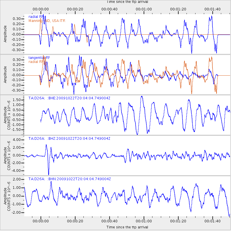
D26A Manning, ND, USA - Earthquake Result Viewer
*The percent match for this event was below the threshold and hence no stack was calculated.
| Earthquake location: |
Hindu Kush Region, Afghanistan |
| Earthquake latitude/longitude: |
36.5/70.9 |
| Earthquake time(UTC): |
2009/10/22 (295) 19:51:27 GMT |
| Earthquake Depth: |
186 km |
| Earthquake Magnitude: |
6.1 MB, 6.2 MW, 6.1 MW |
| Earthquake Catalog/Contributor: |
WHDF/NEIC |
|
| Network: |
TA USArray Transportable Network (new EarthScope stations) |
| Station: |
D26A Manning, ND, USA |
| Lat/Lon: |
47.03 N/102.44 W |
| Elevation: |
693 m |
|
| Distance: |
96.6 deg |
| Az: |
355.45 deg |
| Baz: |
5.36 deg |
| Ray Param: |
$rayparam |
*The percent match for this event was below the threshold and hence was not used in the summary stack. |
|
| Radial Match: |
44.860725 % |
| Radial Bump: |
338 |
| Transverse Match: |
54.170692 % |
| Transverse Bump: |
315 |
| SOD ConfigId: |
2622 |
| Insert Time: |
2010-03-07 06:14:42.352 +0000 |
| GWidth: |
2.5 |
| Max Bumps: |
400 |
| Tol: |
0.001 |
|
Signal To Noise
| Channel | StoN | STA | LTA |
| TA:D26A: :BHZ:20091022T20:04:04.749004Z | 7.524144 | 1.7188837E-6 | 2.2844907E-7 |
| TA:D26A: :BHN:20091022T20:04:04.749004Z | 0.24126518 | 2.5190178E-7 | 1.0440867E-6 |
| TA:D26A: :BHE:20091022T20:04:04.749004Z | 1.365229 | 6.6484023E-7 | 4.8698075E-7 |
| Arrivals |
| Ps | |
| PpPs | |
| PsPs/PpSs | |


