You are here: Home > Network List > TA - USArray Transportable Network (new EarthScope stations) Stations List
> Station J26A Sides Ranch, Smithwick, SD, USA > Earthquake Result Viewer
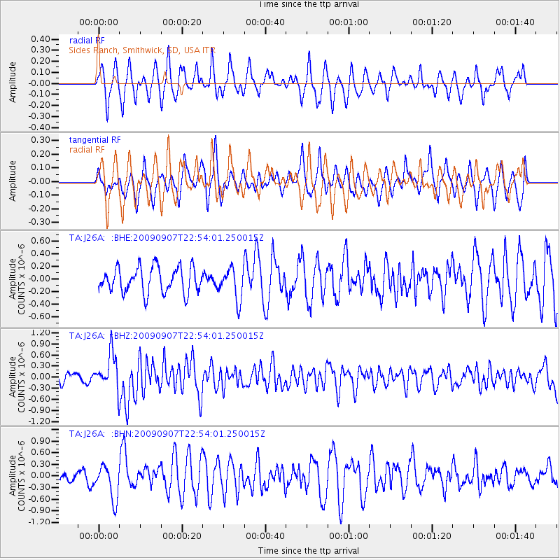
J26A Sides Ranch, Smithwick, SD, USA - Earthquake Result Viewer
*The percent match for this event was below the threshold and hence no stack was calculated.
| Earthquake location: |
Northwestern Caucasus |
| Earthquake latitude/longitude: |
42.7/43.4 |
| Earthquake time(UTC): |
2009/09/07 (250) 22:41:37 GMT |
| Earthquake Depth: |
15 km |
| Earthquake Magnitude: |
5.7 MB, 5.8 MS, 6.0 MW, 5.9 MW |
| Earthquake Catalog/Contributor: |
WHDF/NEIC |
|
| Network: |
TA USArray Transportable Network (new EarthScope stations) |
| Station: |
J26A Sides Ranch, Smithwick, SD, USA |
| Lat/Lon: |
43.31 N/103.08 W |
| Elevation: |
993 m |
|
| Distance: |
89.3 deg |
| Az: |
336.253 deg |
| Baz: |
24.015 deg |
| Ray Param: |
$rayparam |
*The percent match for this event was below the threshold and hence was not used in the summary stack. |
|
| Radial Match: |
66.114815 % |
| Radial Bump: |
333 |
| Transverse Match: |
55.35751 % |
| Transverse Bump: |
352 |
| SOD ConfigId: |
2622 |
| Insert Time: |
2010-03-07 06:15:17.573 +0000 |
| GWidth: |
2.5 |
| Max Bumps: |
400 |
| Tol: |
0.001 |
|
Signal To Noise
| Channel | StoN | STA | LTA |
| TA:J26A: :BHZ:20090907T22:54:01.250015Z | 3.1103926 | 5.056294E-7 | 1.6256128E-7 |
| TA:J26A: :BHN:20090907T22:54:01.250015Z | 2.3816416 | 4.5446012E-7 | 1.90818E-7 |
| TA:J26A: :BHE:20090907T22:54:01.250015Z | 1.2976437 | 2.6307663E-7 | 2.0273411E-7 |
| Arrivals |
| Ps | |
| PpPs | |
| PsPs/PpSs | |


