You are here: Home > Network List > TS - TERRAscope (Southern California Seismic Network) Stations List
> Station PAS Pasadena, California, USA > Earthquake Result Viewer
PAS Pasadena, California, USA - Earthquake Result Viewer
| Earthquake location: |
Kuril Islands |
| Earthquake latitude/longitude: |
43.7/147.6 |
| Earthquake time(UTC): |
1996/05/07 (128) 23:20:00 GMT |
| Earthquake Depth: |
54 km |
| Earthquake Magnitude: |
6.2 MB, 5.6 MS, 6.2 UNKNOWN, 5.2 MS |
| Earthquake Catalog/Contributor: |
WHDF/NEIC |
|
| Network: |
TS TERRAscope (Southern California Seismic Network) |
| Station: |
PAS Pasadena, California, USA |
| Lat/Lon: |
34.15 N/118.17 W |
| Elevation: |
295 m |
|
| Distance: |
70.1 deg |
| Az: |
61.598 deg |
| Baz: |
309.721 deg |
| Ray Param: |
0.055098783 |
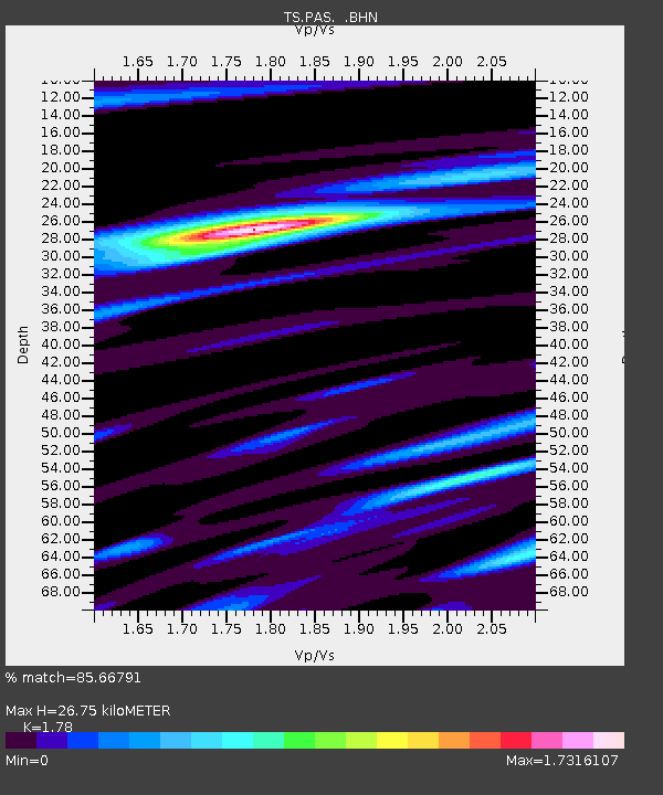
| Estimated Moho Depth: |
26.75 km |
| Estimated Crust Vp/Vs: |
1.78 |
| Assumed Crust Vp: |
6.1 km/s |
| Estimated Crust Vs: |
3.427 km/s |
| Estimated Crust Poisson's Ratio: |
0.27 |
|
| Radial Match: |
85.66791 % |
| Radial Bump: |
400 |
| Transverse Match: |
74.081116 % |
| Transverse Bump: |
400 |
| SOD ConfigId: |
6273 |
| Insert Time: |
2010-02-26 14:36:38.364 +0000 |
| GWidth: |
2.5 |
| Max Bumps: |
400 |
| Tol: |
0.001 |
|
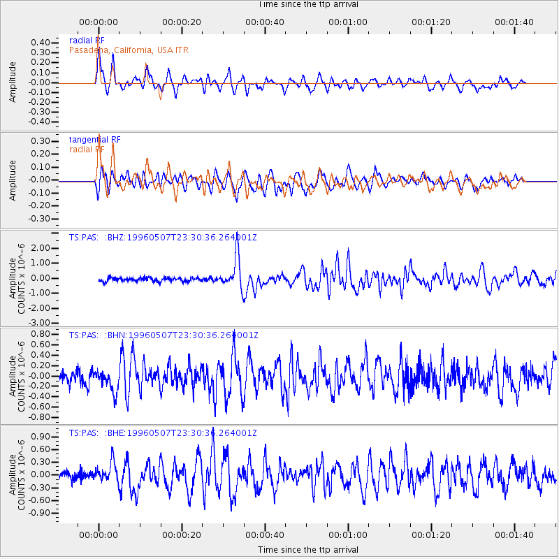
Signal To Noise
| Channel | StoN | STA | LTA |
| TS:PAS: :BHN:19960507T23:30:36.264001Z | 1.6677836 | 2.4535154E-7 | 1.4711235E-7 |
| TS:PAS: :BHE:19960507T23:30:36.264001Z | 2.0795233 | 2.411144E-7 | 1.1594696E-7 |
| TS:PAS: :BHZ:19960507T23:30:36.264001Z | 9.473843 | 1.105354E-6 | 1.16674315E-7 |
| Arrivals |
| Ps | 3.5 SECOND |
| PpPs | 12 SECOND |
| PsPs/PpSs | 15 SECOND |


