You are here: Home > Network List > O2 - Oklahoma Consolidated Temporary Seismic Networks Stations List
> Station SC17 Lindsey, Oklahoma, USA > Earthquake Result Viewer
SC17 Lindsey, Oklahoma, USA - Earthquake Result Viewer
| Earthquake location: |
Albania |
| Earthquake latitude/longitude: |
41.4/19.5 |
| Earthquake time(UTC): |
2019/11/26 (330) 02:54:10 GMT |
| Earthquake Depth: |
10 km |
| Earthquake Magnitude: |
6.4 Mww |
| Earthquake Catalog/Contributor: |
NEIC PDE/us |
|
| Network: |
O2 Oklahoma Consolidated Temporary Seismic Networks |
| Station: |
SC17 Lindsey, Oklahoma, USA |
| Lat/Lon: |
34.92 N/97.60 W |
| Elevation: |
1126 m |
|
| Distance: |
84.6 deg |
| Az: |
312.697 deg |
| Baz: |
42.268 deg |
| Ray Param: |
0.045368727 |
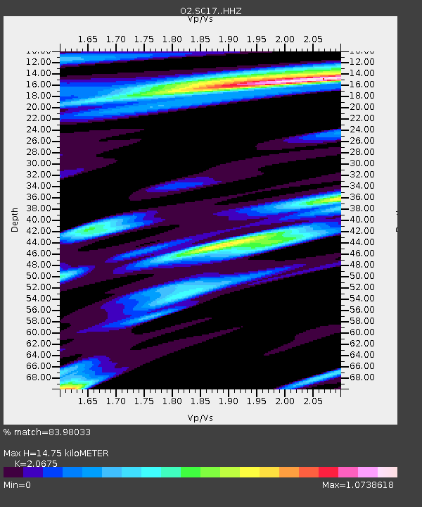
| Estimated Moho Depth: |
14.75 km |
| Estimated Crust Vp/Vs: |
2.07 |
| Assumed Crust Vp: |
6.426 km/s |
| Estimated Crust Vs: |
3.108 km/s |
| Estimated Crust Poisson's Ratio: |
0.35 |
|
| Radial Match: |
83.98033 % |
| Radial Bump: |
400 |
| Transverse Match: |
49.085667 % |
| Transverse Bump: |
389 |
| SOD ConfigId: |
19951751 |
| Insert Time: |
2019-12-10 03:06:25.187 +0000 |
| GWidth: |
2.5 |
| Max Bumps: |
400 |
| Tol: |
0.001 |
|

Signal To Noise
| Channel | StoN | STA | LTA |
| O2:SC17: :HHZ:20191126T03:06:12.91498Z | 1.3206613 | 3.8367347E-7 | 2.9051617E-7 |
| O2:SC17: :HHN:20191126T03:06:12.91498Z | 2.3051019 | 1.1435362E-6 | 4.960892E-7 |
| O2:SC17: :HHE:20191126T03:06:12.91498Z | 1.9601846 | 9.1236905E-7 | 4.654506E-7 |
| Arrivals |
| Ps | 2.5 SECOND |
| PpPs | 6.9 SECOND |
| PsPs/PpSs | 9.4 SECOND |


