You are here: Home > Network List > O2 - Oklahoma Consolidated Temporary Seismic Networks Stations List
> Station PW18 Morrison, Oklahoma, USA > Earthquake Result Viewer
PW18 Morrison, Oklahoma, USA - Earthquake Result Viewer
| Earthquake location: |
Albania |
| Earthquake latitude/longitude: |
41.4/19.5 |
| Earthquake time(UTC): |
2019/11/26 (330) 02:54:10 GMT |
| Earthquake Depth: |
10 km |
| Earthquake Magnitude: |
6.4 Mww |
| Earthquake Catalog/Contributor: |
NEIC PDE/us |
|
| Network: |
O2 Oklahoma Consolidated Temporary Seismic Networks |
| Station: |
PW18 Morrison, Oklahoma, USA |
| Lat/Lon: |
36.28 N/97.04 W |
| Elevation: |
299 m |
|
| Distance: |
83.3 deg |
| Az: |
313.285 deg |
| Baz: |
42.651 deg |
| Ray Param: |
0.046294704 |
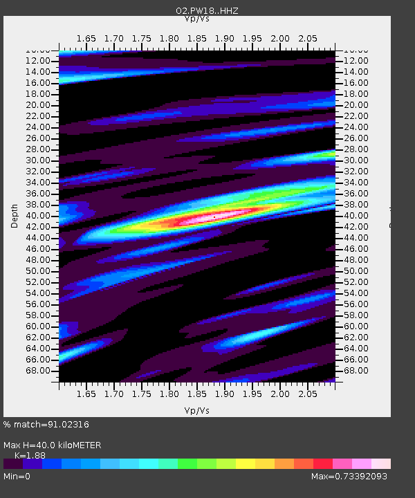
| Estimated Moho Depth: |
40.0 km |
| Estimated Crust Vp/Vs: |
1.88 |
| Assumed Crust Vp: |
6.483 km/s |
| Estimated Crust Vs: |
3.448 km/s |
| Estimated Crust Poisson's Ratio: |
0.30 |
|
| Radial Match: |
91.02316 % |
| Radial Bump: |
324 |
| Transverse Match: |
63.247272 % |
| Transverse Bump: |
400 |
| SOD ConfigId: |
19951751 |
| Insert Time: |
2019-12-10 03:06:27.399 +0000 |
| GWidth: |
2.5 |
| Max Bumps: |
400 |
| Tol: |
0.001 |
|

Signal To Noise
| Channel | StoN | STA | LTA |
| O2:PW18: :HHZ:20191126T03:06:06.270021Z | 3.509337 | 5.866163E-7 | 1.6715873E-7 |
| O2:PW18: :HHN:20191126T03:06:06.270021Z | 1.4929993 | 3.959272E-7 | 2.6518913E-7 |
| O2:PW18: :HHE:20191126T03:06:06.270021Z | 1.1095026 | 3.6314918E-7 | 3.273081E-7 |
| Arrivals |
| Ps | 5.6 SECOND |
| PpPs | 17 SECOND |
| PsPs/PpSs | 23 SECOND |


