You are here: Home > Network List > TA - USArray Transportable Network (new EarthScope stations) Stations List
> Station E20K Nigu River, AK, USA > Earthquake Result Viewer
E20K Nigu River, AK, USA - Earthquake Result Viewer
| Earthquake location: |
Albania |
| Earthquake latitude/longitude: |
41.4/19.5 |
| Earthquake time(UTC): |
2019/11/26 (330) 02:54:10 GMT |
| Earthquake Depth: |
10 km |
| Earthquake Magnitude: |
6.4 Mww |
| Earthquake Catalog/Contributor: |
NEIC PDE/us |
|
| Network: |
TA USArray Transportable Network (new EarthScope stations) |
| Station: |
E20K Nigu River, AK, USA |
| Lat/Lon: |
68.26 N/156.19 W |
| Elevation: |
866 m |
|
| Distance: |
70.6 deg |
| Az: |
358.292 deg |
| Baz: |
3.449 deg |
| Ray Param: |
0.054877717 |
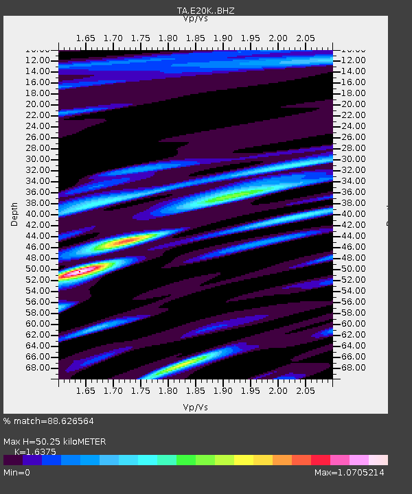
| Estimated Moho Depth: |
50.25 km |
| Estimated Crust Vp/Vs: |
1.64 |
| Assumed Crust Vp: |
6.221 km/s |
| Estimated Crust Vs: |
3.799 km/s |
| Estimated Crust Poisson's Ratio: |
0.20 |
|
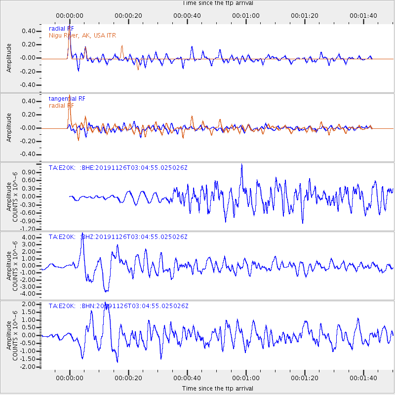
| Radial Match: |
88.626564 % |
| Radial Bump: |
400 |
| Transverse Match: |
82.166954 % |
| Transverse Bump: |
400 |
| SOD ConfigId: |
19951751 |
| Insert Time: |
2019-12-10 03:07:56.063 +0000 |
| GWidth: |
2.5 |
| Max Bumps: |
400 |
| Tol: |
0.001 |
|
Signal To Noise
| Channel | StoN | STA | LTA |
| TA:E20K: :BHZ:20191126T03:04:55.025026Z | 9.487544 | 1.7190853E-6 | 1.8119391E-7 |
| TA:E20K: :BHN:20191126T03:04:55.025026Z | 5.373302 | 6.0263926E-7 | 1.1215436E-7 |
| TA:E20K: :BHE:20191126T03:04:55.025026Z | 1.1156161 | 1.169741E-7 | 1.04851566E-7 |
| Arrivals |
| Ps | 5.3 SECOND |
| PpPs | 21 SECOND |
| PsPs/PpSs | 26 SECOND |


