You are here: Home > Network List > TA - USArray Transportable Network (new EarthScope stations) Stations List
> Station F21K Alatna River, AK, USA > Earthquake Result Viewer
F21K Alatna River, AK, USA - Earthquake Result Viewer
| Earthquake location: |
Albania |
| Earthquake latitude/longitude: |
41.4/19.5 |
| Earthquake time(UTC): |
2019/11/26 (330) 02:54:10 GMT |
| Earthquake Depth: |
10 km |
| Earthquake Magnitude: |
6.4 Mww |
| Earthquake Catalog/Contributor: |
NEIC PDE/us |
|
| Network: |
TA USArray Transportable Network (new EarthScope stations) |
| Station: |
F21K Alatna River, AK, USA |
| Lat/Lon: |
67.22 N/153.48 W |
| Elevation: |
597 m |
|
| Distance: |
71.6 deg |
| Az: |
357.119 deg |
| Baz: |
5.57 deg |
| Ray Param: |
0.054251686 |
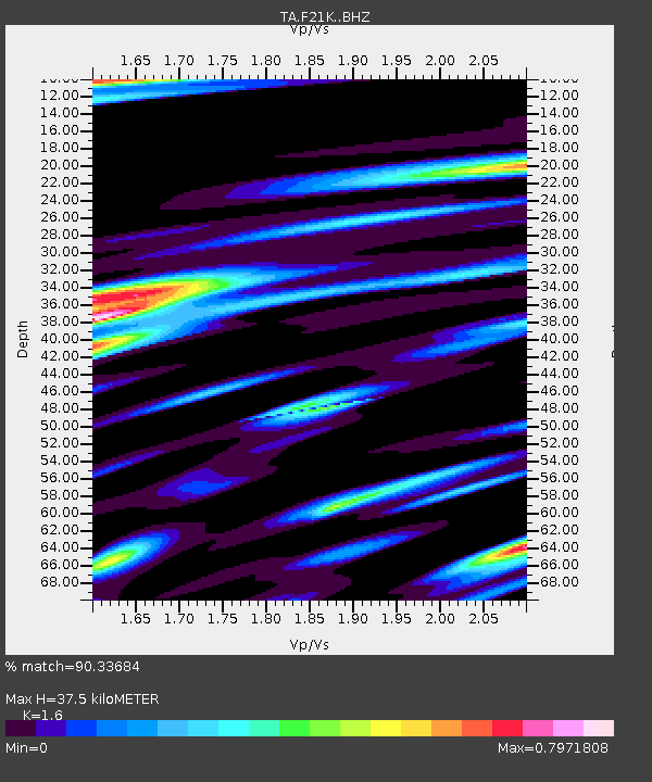
| Estimated Moho Depth: |
37.5 km |
| Estimated Crust Vp/Vs: |
1.60 |
| Assumed Crust Vp: |
6.455 km/s |
| Estimated Crust Vs: |
4.035 km/s |
| Estimated Crust Poisson's Ratio: |
0.18 |
|
| Radial Match: |
90.33684 % |
| Radial Bump: |
400 |
| Transverse Match: |
85.01808 % |
| Transverse Bump: |
400 |
| SOD ConfigId: |
19951751 |
| Insert Time: |
2019-12-10 03:08:06.222 +0000 |
| GWidth: |
2.5 |
| Max Bumps: |
400 |
| Tol: |
0.001 |
|
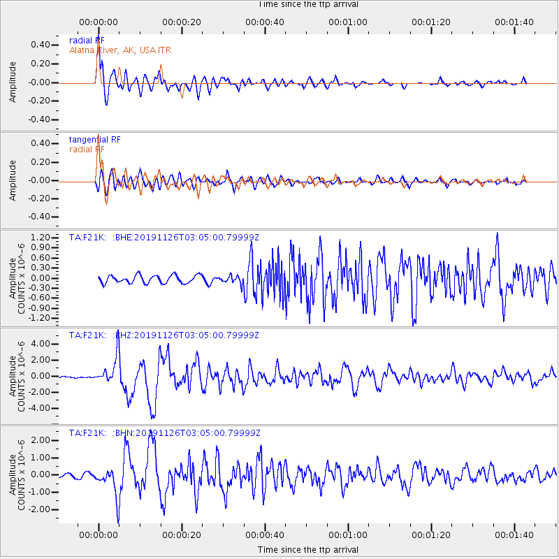
Signal To Noise
| Channel | StoN | STA | LTA |
| TA:F21K: :BHZ:20191126T03:05:00.79999Z | 13.4507475 | 1.8354058E-6 | 1.364538E-7 |
| TA:F21K: :BHN:20191126T03:05:00.79999Z | 4.9034233 | 8.5197325E-7 | 1.737507E-7 |
| TA:F21K: :BHE:20191126T03:05:00.79999Z | 0.9475489 | 1.0833382E-7 | 1.1433058E-7 |
| Arrivals |
| Ps | 3.6 SECOND |
| PpPs | 15 SECOND |
| PsPs/PpSs | 18 SECOND |


