You are here: Home > Network List > TA - USArray Transportable Network (new EarthScope stations) Stations List
> Station G16K Koyuk River, AK, USA > Earthquake Result Viewer
G16K Koyuk River, AK, USA - Earthquake Result Viewer
| Earthquake location: |
Albania |
| Earthquake latitude/longitude: |
41.4/19.5 |
| Earthquake time(UTC): |
2019/11/26 (330) 02:54:10 GMT |
| Earthquake Depth: |
10 km |
| Earthquake Magnitude: |
6.4 Mww |
| Earthquake Catalog/Contributor: |
NEIC PDE/us |
|
| Network: |
TA USArray Transportable Network (new EarthScope stations) |
| Station: |
G16K Koyuk River, AK, USA |
| Lat/Lon: |
65.39 N/162.35 W |
| Elevation: |
169 m |
|
| Distance: |
73.5 deg |
| Az: |
0.803 deg |
| Baz: |
358.558 deg |
| Ray Param: |
0.052954223 |
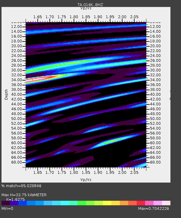
| Estimated Moho Depth: |
33.75 km |
| Estimated Crust Vp/Vs: |
1.63 |
| Assumed Crust Vp: |
6.276 km/s |
| Estimated Crust Vs: |
3.856 km/s |
| Estimated Crust Poisson's Ratio: |
0.20 |
|
| Radial Match: |
85.028946 % |
| Radial Bump: |
395 |
| Transverse Match: |
74.72598 % |
| Transverse Bump: |
400 |
| SOD ConfigId: |
19951751 |
| Insert Time: |
2019-12-10 03:08:12.790 +0000 |
| GWidth: |
2.5 |
| Max Bumps: |
400 |
| Tol: |
0.001 |
|

Signal To Noise
| Channel | StoN | STA | LTA |
| TA:G16K: :BHZ:20191126T03:05:12.450014Z | 7.189894 | 1.9082972E-6 | 2.6541383E-7 |
| TA:G16K: :BHN:20191126T03:05:12.450014Z | 4.1584983 | 7.785088E-7 | 1.8720914E-7 |
| TA:G16K: :BHE:20191126T03:05:12.450014Z | 0.96397084 | 2.2910959E-7 | 2.3767274E-7 |
| Arrivals |
| Ps | 3.5 SECOND |
| PpPs | 14 SECOND |
| PsPs/PpSs | 17 SECOND |


