You are here: Home > Network List > TA - USArray Transportable Network (new EarthScope stations) Stations List
> Station G18K Tagagawik, AK, USA > Earthquake Result Viewer
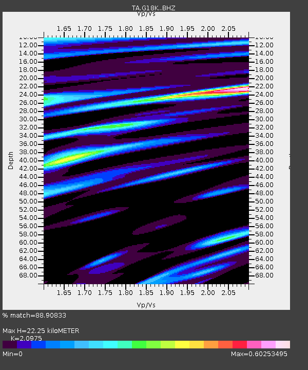
G18K Tagagawik, AK, USA - Earthquake Result Viewer
| Earthquake location: |
Albania |
| Earthquake latitude/longitude: |
41.4/19.5 |
| Earthquake time(UTC): |
2019/11/26 (330) 02:54:10 GMT |
| Earthquake Depth: |
10 km |
| Earthquake Magnitude: |
6.4 Mww |
| Earthquake Catalog/Contributor: |
NEIC PDE/us |
|
| Network: |
TA USArray Transportable Network (new EarthScope stations) |
| Station: |
G18K Tagagawik, AK, USA |
| Lat/Lon: |
65.89 N/158.65 W |
| Elevation: |
484 m |
|
| Distance: |
73.0 deg |
| Az: |
359.201 deg |
| Baz: |
1.464 deg |
| Ray Param: |
0.05328577 |
| Estimated Moho Depth: |
22.25 km |
| Estimated Crust Vp/Vs: |
2.10 |
| Assumed Crust Vp: |
6.1 km/s |
| Estimated Crust Vs: |
2.908 km/s |
| Estimated Crust Poisson's Ratio: |
0.35 |
|
| Radial Match: |
88.90833 % |
| Radial Bump: |
400 |
| Transverse Match: |
76.65865 % |
| Transverse Bump: |
400 |
| SOD ConfigId: |
19951751 |
| Insert Time: |
2019-12-10 03:08:13.318 +0000 |
| GWidth: |
2.5 |
| Max Bumps: |
400 |
| Tol: |
0.001 |
|

Signal To Noise
| Channel | StoN | STA | LTA |
| TA:G18K: :BHZ:20191126T03:05:09.500002Z | 16.399618 | 1.949997E-6 | 1.1890502E-7 |
| TA:G18K: :BHN:20191126T03:05:09.500002Z | 3.4140198 | 6.8226603E-7 | 1.9984243E-7 |
| TA:G18K: :BHE:20191126T03:05:09.500002Z | 1.258333 | 2.265876E-7 | 1.8006968E-7 |
| Arrivals |
| Ps | 4.1 SECOND |
| PpPs | 11 SECOND |
| PsPs/PpSs | 15 SECOND |


