You are here: Home > Network List > TA - USArray Transportable Network (new EarthScope stations) Stations List
> Station G26K Porcupine River, AK, USA > Earthquake Result Viewer
G26K Porcupine River, AK, USA - Earthquake Result Viewer
| Earthquake location: |
Albania |
| Earthquake latitude/longitude: |
41.4/19.5 |
| Earthquake time(UTC): |
2019/11/26 (330) 02:54:10 GMT |
| Earthquake Depth: |
10 km |
| Earthquake Magnitude: |
6.4 Mww |
| Earthquake Catalog/Contributor: |
NEIC PDE/us |
|
| Network: |
TA USArray Transportable Network (new EarthScope stations) |
| Station: |
G26K Porcupine River, AK, USA |
| Lat/Lon: |
66.95 N/143.78 W |
| Elevation: |
180 m |
|
| Distance: |
71.2 deg |
| Az: |
353.123 deg |
| Baz: |
13.221 deg |
| Ray Param: |
0.054480266 |
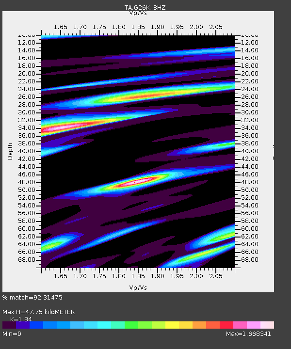
| Estimated Moho Depth: |
47.75 km |
| Estimated Crust Vp/Vs: |
1.84 |
| Assumed Crust Vp: |
6.577 km/s |
| Estimated Crust Vs: |
3.574 km/s |
| Estimated Crust Poisson's Ratio: |
0.29 |
|
| Radial Match: |
92.31475 % |
| Radial Bump: |
400 |
| Transverse Match: |
73.67553 % |
| Transverse Bump: |
400 |
| SOD ConfigId: |
19951751 |
| Insert Time: |
2019-12-10 03:08:16.770 +0000 |
| GWidth: |
2.5 |
| Max Bumps: |
400 |
| Tol: |
0.001 |
|

Signal To Noise
| Channel | StoN | STA | LTA |
| TA:G26K: :BHZ:20191126T03:04:58.700014Z | 16.93531 | 1.6841763E-6 | 9.9447625E-8 |
| TA:G26K: :BHN:20191126T03:04:58.700014Z | 2.6901119 | 6.9441813E-7 | 2.5813728E-7 |
| TA:G26K: :BHE:20191126T03:04:58.700014Z | 0.9556122 | 3.5559063E-7 | 3.721077E-7 |
| Arrivals |
| Ps | 6.3 SECOND |
| PpPs | 20 SECOND |
| PsPs/PpSs | 26 SECOND |


