You are here: Home > Network List > TS - TERRAscope (Southern California Seismic Network) Stations List
> Station PAS Pasadena, California, USA > Earthquake Result Viewer
PAS Pasadena, California, USA - Earthquake Result Viewer
| Earthquake location: |
Near East Coast Of Kamchatka |
| Earthquake latitude/longitude: |
54.8/162.0 |
| Earthquake time(UTC): |
1997/12/05 (339) 11:26:54 GMT |
| Earthquake Depth: |
33 km |
| Earthquake Magnitude: |
6.3 MB, 7.6 MS, 7.9 UNKNOWN, 7.3 ME |
| Earthquake Catalog/Contributor: |
WHDF/NEIC |
|
| Network: |
TS TERRAscope (Southern California Seismic Network) |
| Station: |
PAS Pasadena, California, USA |
| Lat/Lon: |
34.15 N/118.17 W |
| Elevation: |
295 m |
|
| Distance: |
57.3 deg |
| Az: |
76.012 deg |
| Baz: |
317.407 deg |
| Ray Param: |
0.063545905 |
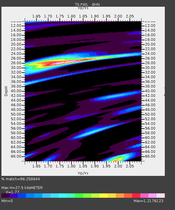
| Estimated Moho Depth: |
27.5 km |
| Estimated Crust Vp/Vs: |
1.77 |
| Assumed Crust Vp: |
6.1 km/s |
| Estimated Crust Vs: |
3.446 km/s |
| Estimated Crust Poisson's Ratio: |
0.27 |
|
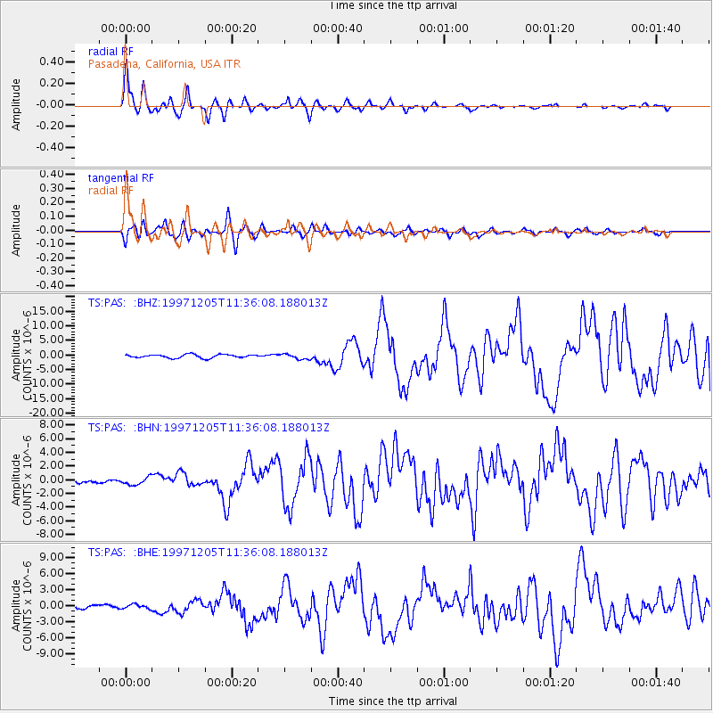
| Radial Match: |
96.258644 % |
| Radial Bump: |
397 |
| Transverse Match: |
87.93263 % |
| Transverse Bump: |
400 |
| SOD ConfigId: |
9875 |
| Insert Time: |
2010-02-26 14:36:42.260 +0000 |
| GWidth: |
2.5 |
| Max Bumps: |
400 |
| Tol: |
0.001 |
|
Signal To Noise
| Channel | StoN | STA | LTA |
| TS:PAS: :BHN:19971205T11:36:08.188013Z | 1.3980167 | 5.505906E-7 | 3.938369E-7 |
| TS:PAS: :BHE:19971205T11:36:08.188013Z | 1.0572641 | 4.1116928E-7 | 3.888993E-7 |
| TS:PAS: :BHZ:19971205T11:36:08.188013Z | 1.4958525 | 9.031043E-7 | 6.037389E-7 |
| Arrivals |
| Ps | 3.6 SECOND |
| PpPs | 12 SECOND |
| PsPs/PpSs | 16 SECOND |


