You are here: Home > Network List > TA - USArray Transportable Network (new EarthScope stations) Stations List
> Station B27A Peters Farms, Glenburn, ND, USA > Earthquake Result Viewer
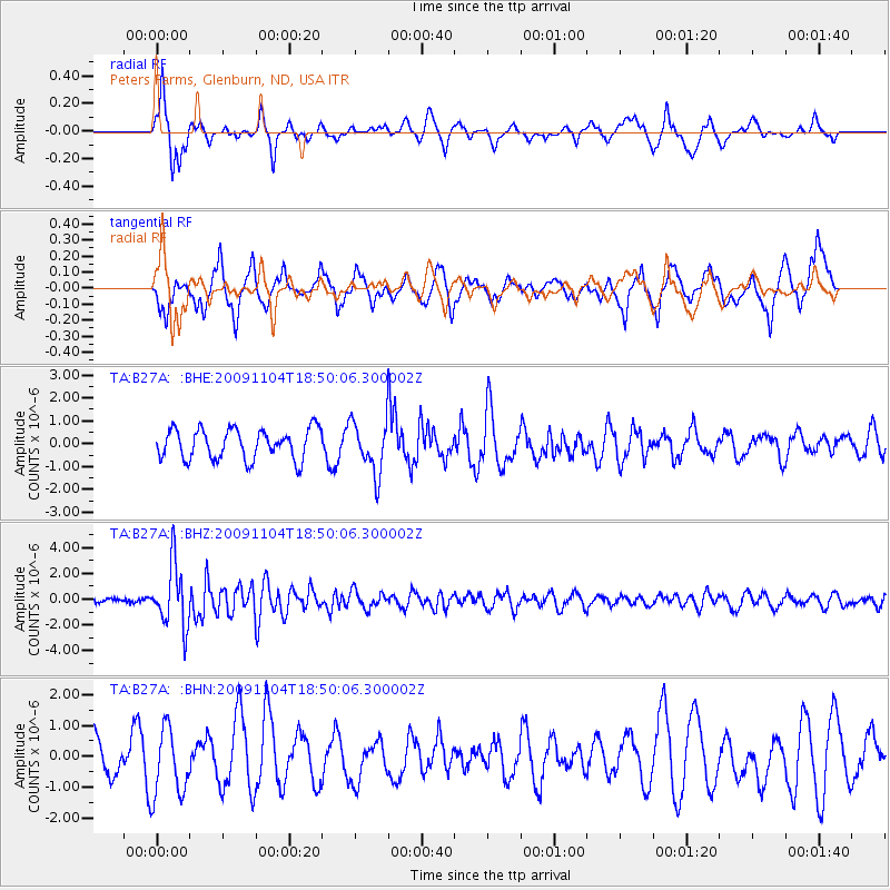
B27A Peters Farms, Glenburn, ND, USA - Earthquake Result Viewer
*The percent match for this event was below the threshold and hence no stack was calculated.
| Earthquake location: |
Azores Islands Region |
| Earthquake latitude/longitude: |
36.2/-33.9 |
| Earthquake time(UTC): |
2009/11/04 (308) 18:41:44 GMT |
| Earthquake Depth: |
10 km |
| Earthquake Magnitude: |
5.7 MB, 5.6 MS, 5.9 MW, 5.8 MW |
| Earthquake Catalog/Contributor: |
WHDF/NEIC |
|
| Network: |
TA USArray Transportable Network (new EarthScope stations) |
| Station: |
B27A Peters Farms, Glenburn, ND, USA |
| Lat/Lon: |
48.40 N/101.26 W |
| Elevation: |
492 m |
|
| Distance: |
49.8 deg |
| Az: |
306.366 deg |
| Baz: |
77.959 deg |
| Ray Param: |
$rayparam |
*The percent match for this event was below the threshold and hence was not used in the summary stack. |
|
| Radial Match: |
68.88037 % |
| Radial Bump: |
335 |
| Transverse Match: |
67.649605 % |
| Transverse Bump: |
395 |
| SOD ConfigId: |
2622 |
| Insert Time: |
2010-03-07 06:15:52.227 +0000 |
| GWidth: |
2.5 |
| Max Bumps: |
400 |
| Tol: |
0.001 |
|
Signal To Noise
| Channel | StoN | STA | LTA |
| TA:B27A: :BHZ:20091104T18:50:06.300002Z | 12.27564 | 2.401664E-6 | 1.9564473E-7 |
| TA:B27A: :BHN:20091104T18:50:06.300002Z | 1.5707037 | 1.1256584E-6 | 7.1665863E-7 |
| TA:B27A: :BHE:20091104T18:50:06.300002Z | 1.740715 | 1.1493272E-6 | 6.6026155E-7 |
| Arrivals |
| Ps | |
| PpPs | |
| PsPs/PpSs | |


