You are here: Home > Network List > TA - USArray Transportable Network (new EarthScope stations) Stations List
> Station H31M Peel River, Yukon, CAN > Earthquake Result Viewer
H31M Peel River, Yukon, CAN - Earthquake Result Viewer
| Earthquake location: |
Albania |
| Earthquake latitude/longitude: |
41.4/19.5 |
| Earthquake time(UTC): |
2019/11/26 (330) 02:54:10 GMT |
| Earthquake Depth: |
10 km |
| Earthquake Magnitude: |
6.4 Mww |
| Earthquake Catalog/Contributor: |
NEIC PDE/us |
|
| Network: |
TA USArray Transportable Network (new EarthScope stations) |
| Station: |
H31M Peel River, Yukon, CAN |
| Lat/Lon: |
65.81 N/134.34 W |
| Elevation: |
642 m |
|
| Distance: |
71.2 deg |
| Az: |
348.928 deg |
| Baz: |
20.514 deg |
| Ray Param: |
0.05448398 |
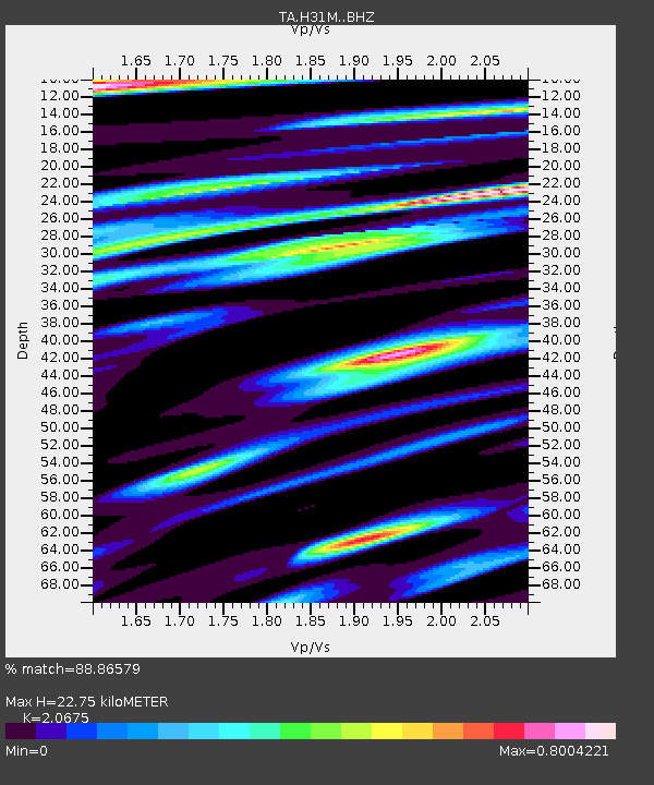
| Estimated Moho Depth: |
22.75 km |
| Estimated Crust Vp/Vs: |
2.07 |
| Assumed Crust Vp: |
6.419 km/s |
| Estimated Crust Vs: |
3.105 km/s |
| Estimated Crust Poisson's Ratio: |
0.35 |
|
| Radial Match: |
88.86579 % |
| Radial Bump: |
400 |
| Transverse Match: |
74.836205 % |
| Transverse Bump: |
400 |
| SOD ConfigId: |
19951751 |
| Insert Time: |
2019-12-10 03:08:23.930 +0000 |
| GWidth: |
2.5 |
| Max Bumps: |
400 |
| Tol: |
0.001 |
|
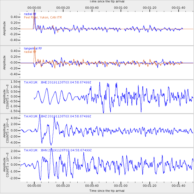
Signal To Noise
| Channel | StoN | STA | LTA |
| TA:H31M: :BHZ:20191126T03:04:58.67499Z | 9.533398 | 1.980252E-6 | 2.0771733E-7 |
| TA:H31M: :BHN:20191126T03:04:58.67499Z | 3.9601233 | 9.4896734E-7 | 2.3963077E-7 |
| TA:H31M: :BHE:20191126T03:04:58.67499Z | 0.35399964 | 1.5144356E-7 | 4.2780707E-7 |
| Arrivals |
| Ps | 3.9 SECOND |
| PpPs | 11 SECOND |
| PsPs/PpSs | 14 SECOND |


