You are here: Home > Network List > TA - USArray Transportable Network (new EarthScope stations) Stations List
> Station M15K Kasigluk River, AK, USA > Earthquake Result Viewer
M15K Kasigluk River, AK, USA - Earthquake Result Viewer
| Earthquake location: |
Albania |
| Earthquake latitude/longitude: |
41.4/19.5 |
| Earthquake time(UTC): |
2019/11/26 (330) 02:54:10 GMT |
| Earthquake Depth: |
10 km |
| Earthquake Magnitude: |
6.4 Mww |
| Earthquake Catalog/Contributor: |
NEIC PDE/us |
|
| Network: |
TA USArray Transportable Network (new EarthScope stations) |
| Station: |
M15K Kasigluk River, AK, USA |
| Lat/Lon: |
60.69 N/160.69 W |
| Elevation: |
210 m |
|
| Distance: |
78.2 deg |
| Az: |
0.087 deg |
| Baz: |
359.867 deg |
| Ray Param: |
0.04977652 |
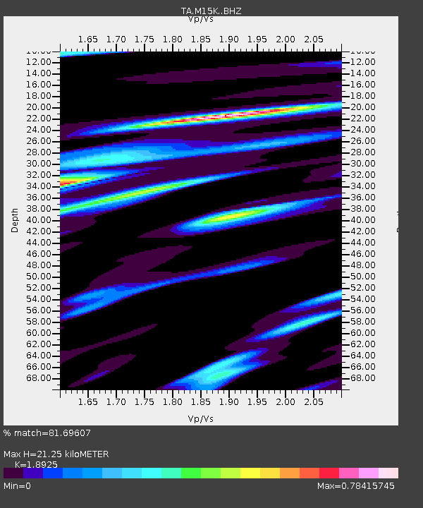
| Estimated Moho Depth: |
21.25 km |
| Estimated Crust Vp/Vs: |
1.89 |
| Assumed Crust Vp: |
6.182 km/s |
| Estimated Crust Vs: |
3.267 km/s |
| Estimated Crust Poisson's Ratio: |
0.31 |
|
| Radial Match: |
81.69607 % |
| Radial Bump: |
400 |
| Transverse Match: |
81.30031 % |
| Transverse Bump: |
400 |
| SOD ConfigId: |
19951751 |
| Insert Time: |
2019-12-10 03:08:38.411 +0000 |
| GWidth: |
2.5 |
| Max Bumps: |
400 |
| Tol: |
0.001 |
|

Signal To Noise
| Channel | StoN | STA | LTA |
| TA:M15K: :BHZ:20191126T03:05:39.375002Z | 5.749112 | 1.642755E-6 | 2.8574064E-7 |
| TA:M15K: :BHN:20191126T03:05:39.375002Z | 2.647737 | 6.764663E-7 | 2.554885E-7 |
| TA:M15K: :BHE:20191126T03:05:39.375002Z | 1.3737824 | 2.882226E-7 | 2.0980222E-7 |
| Arrivals |
| Ps | 3.1 SECOND |
| PpPs | 9.7 SECOND |
| PsPs/PpSs | 13 SECOND |


