You are here: Home > Network List > TS - TERRAscope (Southern California Seismic Network) Stations List
> Station PAS Pasadena, California, USA > Earthquake Result Viewer
PAS Pasadena, California, USA - Earthquake Result Viewer
| Earthquake location: |
Central East Pacific Rise |
| Earthquake latitude/longitude: |
-4.4/-105.7 |
| Earthquake time(UTC): |
1997/08/15 (227) 07:37:49 GMT |
| Earthquake Depth: |
10 km |
| Earthquake Magnitude: |
5.3 MB, 5.8 MS, 6.2 UNKNOWN, 6.1 MW |
| Earthquake Catalog/Contributor: |
WHDF/NEIC |
|
| Network: |
TS TERRAscope (Southern California Seismic Network) |
| Station: |
PAS Pasadena, California, USA |
| Lat/Lon: |
34.15 N/118.17 W |
| Elevation: |
295 m |
|
| Distance: |
40.1 deg |
| Az: |
343.848 deg |
| Baz: |
160.459 deg |
| Ray Param: |
0.07459864 |
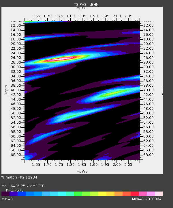
| Estimated Moho Depth: |
26.25 km |
| Estimated Crust Vp/Vs: |
1.76 |
| Assumed Crust Vp: |
6.1 km/s |
| Estimated Crust Vs: |
3.471 km/s |
| Estimated Crust Poisson's Ratio: |
0.26 |
|
| Radial Match: |
92.12934 % |
| Radial Bump: |
288 |
| Transverse Match: |
84.84346 % |
| Transverse Bump: |
335 |
| SOD ConfigId: |
6273 |
| Insert Time: |
2010-02-26 14:36:43.370 +0000 |
| GWidth: |
2.5 |
| Max Bumps: |
400 |
| Tol: |
0.001 |
|

Signal To Noise
| Channel | StoN | STA | LTA |
| TS:PAS: :BHN:19970815T07:44:53.665009Z | 1.8765343 | 2.027529E-7 | 1.08046464E-7 |
| TS:PAS: :BHE:19970815T07:44:53.665009Z | 0.7902551 | 7.8820115E-8 | 9.974008E-8 |
| TS:PAS: :BHZ:19970815T07:44:53.665009Z | 2.8396006 | 2.952583E-7 | 1.0397881E-7 |
| Arrivals |
| Ps | 3.5 SECOND |
| PpPs | 11 SECOND |
| PsPs/PpSs | 15 SECOND |


