You are here: Home > Network List > TA - USArray Transportable Network (new EarthScope stations) Stations List
> Station J27A Elkhorn Farm, Martin, SD, USA > Earthquake Result Viewer
J27A Elkhorn Farm, Martin, SD, USA - Earthquake Result Viewer
| Earthquake location: |
Near Coast Of Venezuela |
| Earthquake latitude/longitude: |
10.7/-67.9 |
| Earthquake time(UTC): |
2009/09/12 (255) 20:06:24 GMT |
| Earthquake Depth: |
10 km |
| Earthquake Magnitude: |
6.3 MB, 6.4 MS, 6.3 MW, 6.3 MW |
| Earthquake Catalog/Contributor: |
WHDF/NEIC |
|
| Network: |
TA USArray Transportable Network (new EarthScope stations) |
| Station: |
J27A Elkhorn Farm, Martin, SD, USA |
| Lat/Lon: |
43.25 N/102.01 W |
| Elevation: |
1081 m |
|
| Distance: |
43.9 deg |
| Az: |
323.794 deg |
| Baz: |
127.385 deg |
| Ray Param: |
0.07226022 |
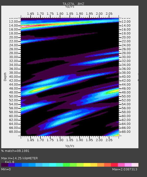
| Estimated Moho Depth: |
14.25 km |
| Estimated Crust Vp/Vs: |
1.60 |
| Assumed Crust Vp: |
6.483 km/s |
| Estimated Crust Vs: |
4.052 km/s |
| Estimated Crust Poisson's Ratio: |
0.18 |
|
| Radial Match: |
89.1891 % |
| Radial Bump: |
372 |
| Transverse Match: |
80.40556 % |
| Transverse Bump: |
349 |
| SOD ConfigId: |
2622 |
| Insert Time: |
2010-03-07 06:15:58.063 +0000 |
| GWidth: |
2.5 |
| Max Bumps: |
400 |
| Tol: |
0.001 |
|

Signal To Noise
| Channel | StoN | STA | LTA |
| TA:J27A: :BHZ:20090912T20:14:00.348986Z | 7.5724306 | 1.0250178E-6 | 1.353618E-7 |
| TA:J27A: :BHN:20090912T20:14:00.348986Z | 1.2794743 | 4.6684542E-7 | 3.6487288E-7 |
| TA:J27A: :BHE:20090912T20:14:00.348986Z | 1.600681 | 7.2379527E-7 | 4.521796E-7 |
| Arrivals |
| Ps | 1.4 SECOND |
| PpPs | 5.3 SECOND |
| PsPs/PpSs | 6.7 SECOND |


