You are here: Home > Network List > GS - US Geological Survey Networks Stations List
> Station DEC06 Boomer > Earthquake Result Viewer
DEC06 Boomer - Earthquake Result Viewer
*The percent match for this event was below the threshold and hence no stack was calculated.
| Earthquake location: |
Near Islands, Aleutian Islands |
| Earthquake latitude/longitude: |
52.8/172.2 |
| Earthquake time(UTC): |
2017/03/27 (086) 10:50:19 GMT |
| Earthquake Depth: |
10 km |
| Earthquake Magnitude: |
6.1 Mww |
| Earthquake Catalog/Contributor: |
NEIC PDE/us |
|
| Network: |
GS US Geological Survey Networks |
| Station: |
DEC06 Boomer |
| Lat/Lon: |
39.90 N/88.95 W |
| Elevation: |
215 m |
|
| Distance: |
64.2 deg |
| Az: |
57.621 deg |
| Baz: |
318.197 deg |
| Ray Param: |
$rayparam |
*The percent match for this event was below the threshold and hence was not used in the summary stack. |
|
| Radial Match: |
55.037785 % |
| Radial Bump: |
400 |
| Transverse Match: |
63.38781 % |
| Transverse Bump: |
400 |
| SOD ConfigId: |
2028011 |
| Insert Time: |
2017-04-10 10:56:01.563 +0000 |
| GWidth: |
2.5 |
| Max Bumps: |
400 |
| Tol: |
0.001 |
|
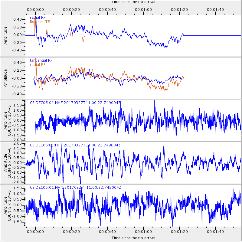
Signal To Noise
| Channel | StoN | STA | LTA |
| GS:DEC06:01:HHZ:20170327T11:00:22.749004Z | 3.120698 | 7.77465E-7 | 2.4913174E-7 |
| GS:DEC06:01:HHN:20170327T11:00:22.749004Z | 1.64973 | 7.488277E-7 | 4.5390925E-7 |
| GS:DEC06:01:HHE:20170327T11:00:22.749004Z | 1.5126085 | 6.5302953E-7 | 4.317241E-7 |
| Arrivals |
| Ps | |
| PpPs | |
| PsPs/PpSs | |


