You are here: Home > Network List > TA - USArray Transportable Network (new EarthScope stations) Stations List
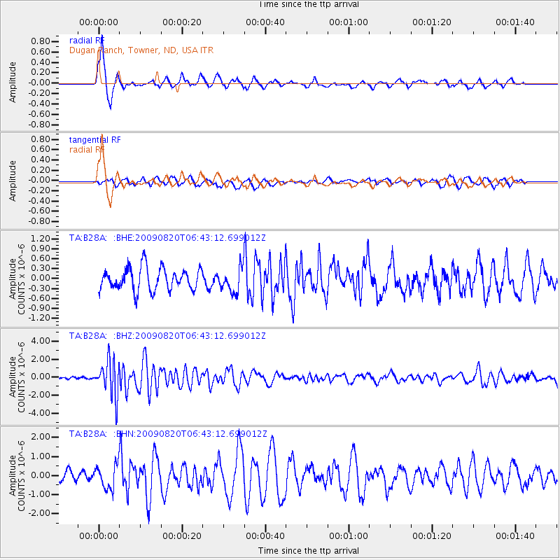
> Station B28A Dugan Ranch, Towner, ND, USA > Earthquake Result Viewer
B28A Dugan Ranch, Towner, ND, USA - Earthquake Result Viewer
| Earthquake location: |
Norwegian Sea |
| Earthquake latitude/longitude: |
72.2/0.9 |
| Earthquake time(UTC): |
2009/08/20 (232) 06:35:04 GMT |
| Earthquake Depth: |
6.0 km |
| Earthquake Magnitude: |
5.9 MB, 5.7 MS, 6.0 MW, 6.0 MW |
| Earthquake Catalog/Contributor: |
WHDF/NEIC |
|
| Network: |
TA USArray Transportable Network (new EarthScope stations) |
| Station: |
B28A Dugan Ranch, Towner, ND, USA |
| Lat/Lon: |
48.45 N/100.36 W |
| Elevation: |
451 m |
|
| Distance: |
47.9 deg |
| Az: |
298.446 deg |
| Baz: |
23.965 deg |
| Ray Param: |
0.06968013 |
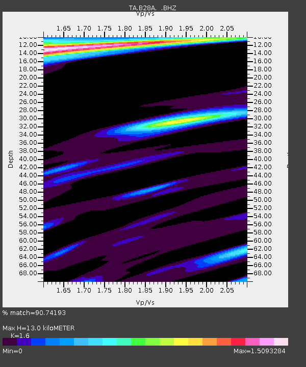
| Estimated Moho Depth: |
13.0 km |
| Estimated Crust Vp/Vs: |
1.60 |
| Assumed Crust Vp: |
6.438 km/s |
| Estimated Crust Vs: |
4.023 km/s |
| Estimated Crust Poisson's Ratio: |
0.18 |
|
| Radial Match: |
90.74193 % |
| Radial Bump: |
310 |
| Transverse Match: |
57.21072 % |
| Transverse Bump: |
395 |
| SOD ConfigId: |
2622 |
| Insert Time: |
2010-03-07 06:16:23.337 +0000 |
| GWidth: |
2.5 |
| Max Bumps: |
400 |
| Tol: |
0.001 |
|
Signal To Noise
| Channel | StoN | STA | LTA |
| TA:B28A: :BHZ:20090820T06:43:12.699012Z | 14.892595 | 1.9952115E-6 | 1.3397339E-7 |
| TA:B28A: :BHN:20090820T06:43:12.699012Z | 2.991432 | 6.3555484E-7 | 2.124584E-7 |
| TA:B28A: :BHE:20090820T06:43:12.699012Z | 1.1353325 | 3.8095627E-7 | 3.35546E-7 |
| Arrivals |
| Ps | 1.3 SECOND |
| PpPs | 4.9 SECOND |
| PsPs/PpSs | 6.2 SECOND |


