You are here: Home > Network List > TA - USArray Transportable Network (new EarthScope stations) Stations List
> Station B28A Dugan Ranch, Towner, ND, USA > Earthquake Result Viewer
B28A Dugan Ranch, Towner, ND, USA - Earthquake Result Viewer
| Earthquake location: |
Off Coast Of Jalisco, Mexico |
| Earthquake latitude/longitude: |
18.8/-107.3 |
| Earthquake time(UTC): |
2009/09/24 (267) 07:16:19 GMT |
| Earthquake Depth: |
10 km |
| Earthquake Magnitude: |
5.8 MB, 6.2 MS, 6.3 MW, 6.3 MW |
| Earthquake Catalog/Contributor: |
WHDF/NEIC |
|
| Network: |
TA USArray Transportable Network (new EarthScope stations) |
| Station: |
B28A Dugan Ranch, Towner, ND, USA |
| Lat/Lon: |
48.45 N/100.36 W |
| Elevation: |
451 m |
|
| Distance: |
30.1 deg |
| Az: |
9.291 deg |
| Baz: |
193.278 deg |
| Ray Param: |
0.07942289 |
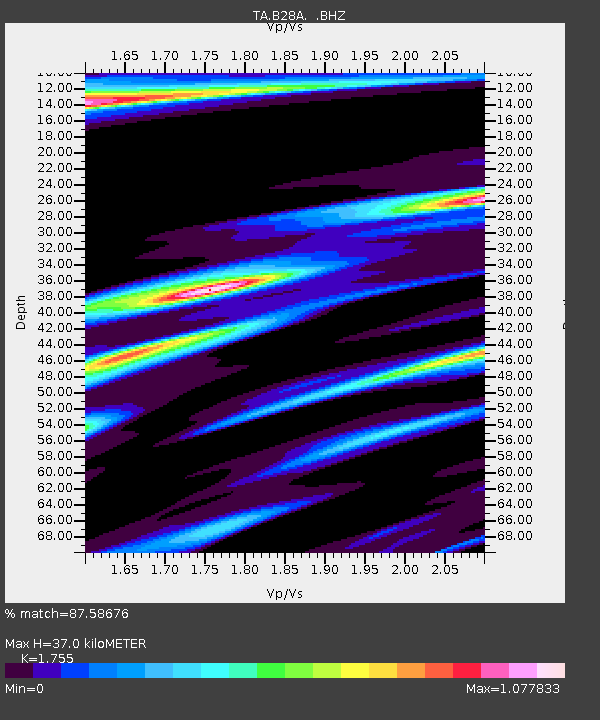
| Estimated Moho Depth: |
37.0 km |
| Estimated Crust Vp/Vs: |
1.75 |
| Assumed Crust Vp: |
6.438 km/s |
| Estimated Crust Vs: |
3.668 km/s |
| Estimated Crust Poisson's Ratio: |
0.26 |
|
| Radial Match: |
87.58676 % |
| Radial Bump: |
306 |
| Transverse Match: |
77.586464 % |
| Transverse Bump: |
385 |
| SOD ConfigId: |
2622 |
| Insert Time: |
2010-03-07 06:16:29.798 +0000 |
| GWidth: |
2.5 |
| Max Bumps: |
400 |
| Tol: |
0.001 |
|
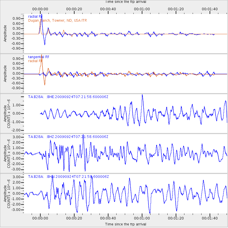
Signal To Noise
| Channel | StoN | STA | LTA |
| TA:B28A: :BHZ:20090924T07:21:58.600006Z | 7.923023 | 1.0938926E-6 | 1.3806505E-7 |
| TA:B28A: :BHN:20090924T07:21:58.600006Z | 1.8545194 | 5.9206667E-7 | 3.1925612E-7 |
| TA:B28A: :BHE:20090924T07:21:58.600006Z | 0.84173614 | 2.4964208E-7 | 2.9657997E-7 |
| Arrivals |
| Ps | 4.7 SECOND |
| PpPs | 15 SECOND |
| PsPs/PpSs | 19 SECOND |


