You are here: Home > Network List > TA - USArray Transportable Network (new EarthScope stations) Stations List
> Station B28A Dugan Ranch, Towner, ND, USA > Earthquake Result Viewer
B28A Dugan Ranch, Towner, ND, USA - Earthquake Result Viewer
| Earthquake location: |
Samoa Islands Region |
| Earthquake latitude/longitude: |
-15.6/-172.0 |
| Earthquake time(UTC): |
2009/09/29 (272) 18:08:21 GMT |
| Earthquake Depth: |
10 km |
| Earthquake Magnitude: |
5.6 MB |
| Earthquake Catalog/Contributor: |
WHDF/NEIC |
|
| Network: |
TA USArray Transportable Network (new EarthScope stations) |
| Station: |
B28A Dugan Ranch, Towner, ND, USA |
| Lat/Lon: |
48.45 N/100.36 W |
| Elevation: |
451 m |
|
| Distance: |
89.8 deg |
| Az: |
39.193 deg |
| Baz: |
246.183 deg |
| Ray Param: |
0.041717328 |
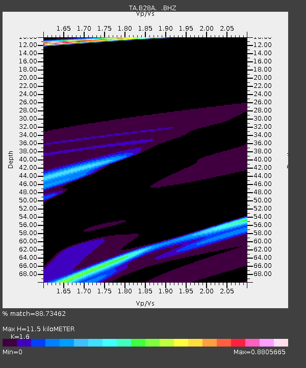
| Estimated Moho Depth: |
11.5 km |
| Estimated Crust Vp/Vs: |
1.60 |
| Assumed Crust Vp: |
6.438 km/s |
| Estimated Crust Vs: |
4.023 km/s |
| Estimated Crust Poisson's Ratio: |
0.18 |
|
| Radial Match: |
88.73462 % |
| Radial Bump: |
371 |
| Transverse Match: |
83.57951 % |
| Transverse Bump: |
400 |
| SOD ConfigId: |
2622 |
| Insert Time: |
2010-03-07 06:16:33.384 +0000 |
| GWidth: |
2.5 |
| Max Bumps: |
400 |
| Tol: |
0.001 |
|

Signal To Noise
| Channel | StoN | STA | LTA |
| TA:B28A: :BHZ:20090929T18:20:49.200022Z | 1.2804297 | 7.40929E-5 | 5.786565E-5 |
| TA:B28A: :BHN:20090929T18:20:49.200022Z | 2.8450565 | 3.7339563E-5 | 1.3124367E-5 |
| TA:B28A: :BHE:20090929T18:20:49.200022Z | 1.2733107 | 9.2003334E-5 | 7.2255214E-5 |
| Arrivals |
| Ps | 1.1 SECOND |
| PpPs | 4.5 SECOND |
| PsPs/PpSs | 5.6 SECOND |


