You are here: Home > Network List > TA - USArray Transportable Network (new EarthScope stations) Stations List
> Station A28A Rude Farm, Bottineau, ND, USA > Earthquake Result Viewer
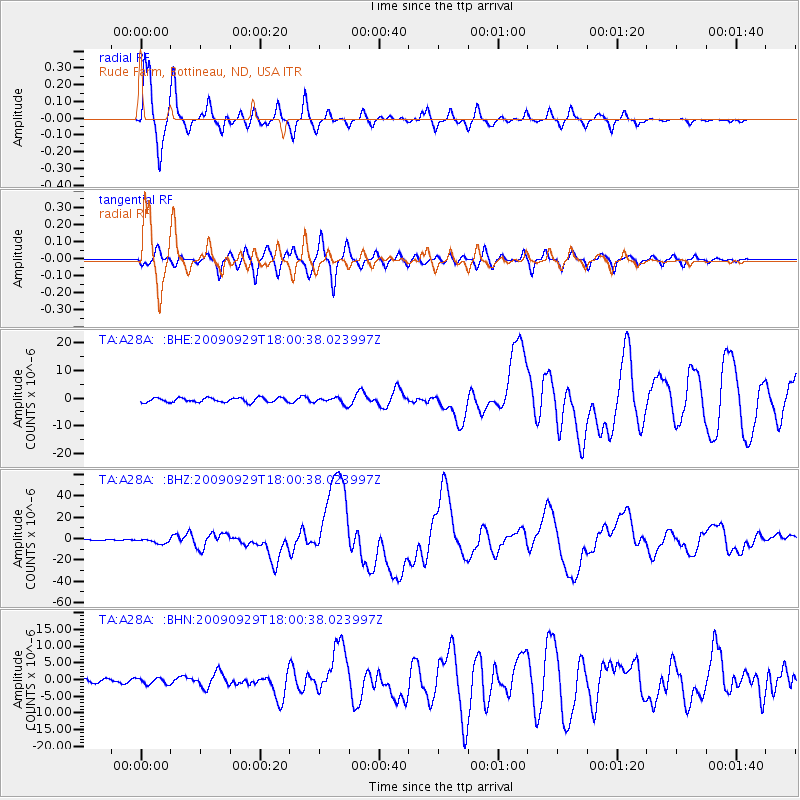
A28A Rude Farm, Bottineau, ND, USA - Earthquake Result Viewer
| Earthquake location: |
Samoa Islands Region |
| Earthquake latitude/longitude: |
-15.5/-172.1 |
| Earthquake time(UTC): |
2009/09/29 (272) 17:48:10 GMT |
| Earthquake Depth: |
18 km |
| Earthquake Magnitude: |
7.1 MB, 8.1 MS, 8.1 MW, 8.0 MW |
| Earthquake Catalog/Contributor: |
WHDF/NEIC |
|
| Network: |
TA USArray Transportable Network (new EarthScope stations) |
| Station: |
A28A Rude Farm, Bottineau, ND, USA |
| Lat/Lon: |
48.91 N/100.27 W |
| Elevation: |
692 m |
|
| Distance: |
90.1 deg |
| Az: |
38.818 deg |
| Baz: |
246.356 deg |
| Ray Param: |
0.041699003 |
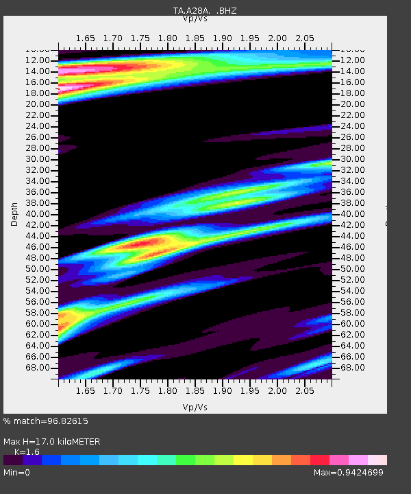
| Estimated Moho Depth: |
17.0 km |
| Estimated Crust Vp/Vs: |
1.60 |
| Assumed Crust Vp: |
6.438 km/s |
| Estimated Crust Vs: |
4.023 km/s |
| Estimated Crust Poisson's Ratio: |
0.18 |
|
| Radial Match: |
96.82615 % |
| Radial Bump: |
400 |
| Transverse Match: |
91.23543 % |
| Transverse Bump: |
400 |
| SOD ConfigId: |
2622 |
| Insert Time: |
2010-03-07 06:16:50.388 +0000 |
| GWidth: |
2.5 |
| Max Bumps: |
400 |
| Tol: |
0.001 |
|
Signal To Noise
| Channel | StoN | STA | LTA |
| TA:A28A: :BHZ:20090929T18:00:38.023997Z | 8.423597 | 2.2397303E-6 | 2.6588762E-7 |
| TA:A28A: :BHN:20090929T18:00:38.023997Z | 1.337123 | 9.029564E-7 | 6.752979E-7 |
| TA:A28A: :BHE:20090929T18:00:38.023997Z | 1.4428895 | 1.1479025E-6 | 7.955581E-7 |
| Arrivals |
| Ps | 1.6 SECOND |
| PpPs | 6.7 SECOND |
| PsPs/PpSs | 8.3 SECOND |


