You are here: Home > Network List > IU - Global Seismograph Network (GSN - IRIS/USGS) Stations List
> Station RSSD Black Hills, South Dakota, USA > Earthquake Result Viewer
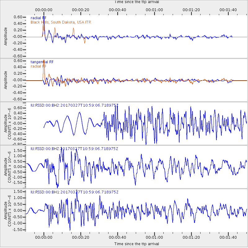
RSSD Black Hills, South Dakota, USA - Earthquake Result Viewer
*The percent match for this event was below the threshold and hence no stack was calculated.
| Earthquake location: |
Near Islands, Aleutian Islands |
| Earthquake latitude/longitude: |
52.8/172.2 |
| Earthquake time(UTC): |
2017/03/27 (086) 10:50:19 GMT |
| Earthquake Depth: |
10 km |
| Earthquake Magnitude: |
6.1 Mww |
| Earthquake Catalog/Contributor: |
NEIC PDE/us |
|
| Network: |
IU Global Seismograph Network (GSN - IRIS/USGS) |
| Station: |
RSSD Black Hills, South Dakota, USA |
| Lat/Lon: |
44.12 N/104.04 W |
| Elevation: |
2090 m |
|
| Distance: |
53.2 deg |
| Az: |
63.362 deg |
| Baz: |
311.095 deg |
| Ray Param: |
$rayparam |
*The percent match for this event was below the threshold and hence was not used in the summary stack. |
|
| Radial Match: |
79.83511 % |
| Radial Bump: |
400 |
| Transverse Match: |
66.586815 % |
| Transverse Bump: |
400 |
| SOD ConfigId: |
2028011 |
| Insert Time: |
2017-04-10 10:57:14.803 +0000 |
| GWidth: |
2.5 |
| Max Bumps: |
400 |
| Tol: |
0.001 |
|
Signal To Noise
| Channel | StoN | STA | LTA |
| IU:RSSD:00:BHZ:20170327T10:59:06.718975Z | 2.005534 | 4.990988E-7 | 2.4886083E-7 |
| IU:RSSD:00:BH1:20170327T10:59:06.718975Z | 3.03106 | 4.738569E-7 | 1.5633373E-7 |
| IU:RSSD:00:BH2:20170327T10:59:06.718975Z | 0.8771259 | 1.8973034E-7 | 2.1630913E-7 |
| Arrivals |
| Ps | |
| PpPs | |
| PsPs/PpSs | |


