You are here: Home > Network List > TS - TERRAscope (Southern California Seismic Network) Stations List
> Station PAS Pasadena, California, USA > Earthquake Result Viewer
PAS Pasadena, California, USA - Earthquake Result Viewer
| Earthquake location: |
Fiji Islands Region |
| Earthquake latitude/longitude: |
-21.6/-176.4 |
| Earthquake time(UTC): |
1998/12/27 (361) 00:38:26 GMT |
| Earthquake Depth: |
144 km |
| Earthquake Magnitude: |
6.1 MB, 6.9 UNKNOWN, 6.6 ME |
| Earthquake Catalog/Contributor: |
WHDF/NEIC |
|
| Network: |
TS TERRAscope (Southern California Seismic Network) |
| Station: |
PAS Pasadena, California, USA |
| Lat/Lon: |
34.15 N/118.17 W |
| Elevation: |
295 m |
|
| Distance: |
78.4 deg |
| Az: |
46.028 deg |
| Baz: |
233.842 deg |
| Ray Param: |
0.049348418 |
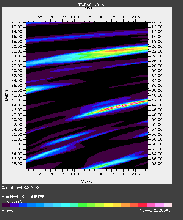
| Estimated Moho Depth: |
44.0 km |
| Estimated Crust Vp/Vs: |
2.00 |
| Assumed Crust Vp: |
6.1 km/s |
| Estimated Crust Vs: |
3.058 km/s |
| Estimated Crust Poisson's Ratio: |
0.33 |
|
| Radial Match: |
93.82693 % |
| Radial Bump: |
352 |
| Transverse Match: |
83.12048 % |
| Transverse Bump: |
400 |
| SOD ConfigId: |
9875 |
| Insert Time: |
2010-02-26 14:36:52.621 +0000 |
| GWidth: |
2.5 |
| Max Bumps: |
400 |
| Tol: |
0.001 |
|
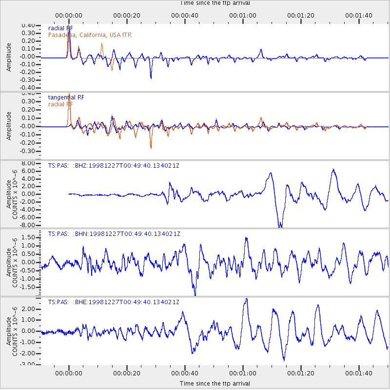
Signal To Noise
| Channel | StoN | STA | LTA |
| TS:PAS: :BHN:19981227T00:49:40.134021Z | 0.92899054 | 2.165116E-7 | 2.3306114E-7 |
| TS:PAS: :BHE:19981227T00:49:40.134021Z | 1.6077833 | 2.1177452E-7 | 1.3171831E-7 |
| TS:PAS: :BHZ:19981227T00:49:40.134021Z | 5.794185 | 9.793171E-7 | 1.6901723E-7 |
| Arrivals |
| Ps | 7.3 SECOND |
| PpPs | 21 SECOND |
| PsPs/PpSs | 28 SECOND |


