You are here: Home > Network List > IU - Global Seismograph Network (GSN - IRIS/USGS) Stations List
> Station XMAS Kiritimati Island, Republic of Kiribati > Earthquake Result Viewer
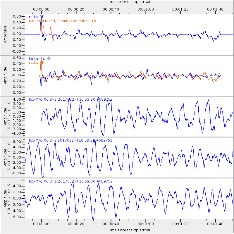
XMAS Kiritimati Island, Republic of Kiribati - Earthquake Result Viewer
*The percent match for this event was below the threshold and hence no stack was calculated.
| Earthquake location: |
Near Islands, Aleutian Islands |
| Earthquake latitude/longitude: |
52.8/172.2 |
| Earthquake time(UTC): |
2017/03/27 (086) 10:50:19 GMT |
| Earthquake Depth: |
10 km |
| Earthquake Magnitude: |
6.1 Mww |
| Earthquake Catalog/Contributor: |
NEIC PDE/us |
|
| Network: |
IU Global Seismograph Network (GSN - IRIS/USGS) |
| Station: |
XMAS Kiritimati Island, Republic of Kiribati |
| Lat/Lon: |
2.04 N/157.45 W |
| Elevation: |
20 m |
|
| Distance: |
56.5 deg |
| Az: |
142.73 deg |
| Baz: |
338.411 deg |
| Ray Param: |
$rayparam |
*The percent match for this event was below the threshold and hence was not used in the summary stack. |
|
| Radial Match: |
72.74067 % |
| Radial Bump: |
400 |
| Transverse Match: |
53.317696 % |
| Transverse Bump: |
400 |
| SOD ConfigId: |
2028011 |
| Insert Time: |
2017-04-10 10:57:29.613 +0000 |
| GWidth: |
2.5 |
| Max Bumps: |
400 |
| Tol: |
0.001 |
|
Signal To Noise
| Channel | StoN | STA | LTA |
| IU:XMAS:00:BHZ:20170327T10:59:30.468975Z | 1.7883272 | 4.355249E-6 | 2.435376E-6 |
| IU:XMAS:00:BH1:20170327T10:59:30.468975Z | 0.53654414 | 1.005467E-6 | 1.8739687E-6 |
| IU:XMAS:00:BH2:20170327T10:59:30.468975Z | 1.6124762 | 2.8780555E-6 | 1.784867E-6 |
| Arrivals |
| Ps | |
| PpPs | |
| PsPs/PpSs | |


