You are here: Home > Network List > TA - USArray Transportable Network (new EarthScope stations) Stations List
> Station D28A Regan, ND, USA > Earthquake Result Viewer
D28A Regan, ND, USA - Earthquake Result Viewer
| Earthquake location: |
Norwegian Sea |
| Earthquake latitude/longitude: |
72.2/0.9 |
| Earthquake time(UTC): |
2009/08/20 (232) 06:35:04 GMT |
| Earthquake Depth: |
6.0 km |
| Earthquake Magnitude: |
5.9 MB, 5.7 MS, 6.0 MW, 6.0 MW |
| Earthquake Catalog/Contributor: |
WHDF/NEIC |
|
| Network: |
TA USArray Transportable Network (new EarthScope stations) |
| Station: |
D28A Regan, ND, USA |
| Lat/Lon: |
47.19 N/100.57 W |
| Elevation: |
621 m |
|
| Distance: |
49.2 deg |
| Az: |
297.942 deg |
| Baz: |
23.478 deg |
| Ray Param: |
0.06889495 |
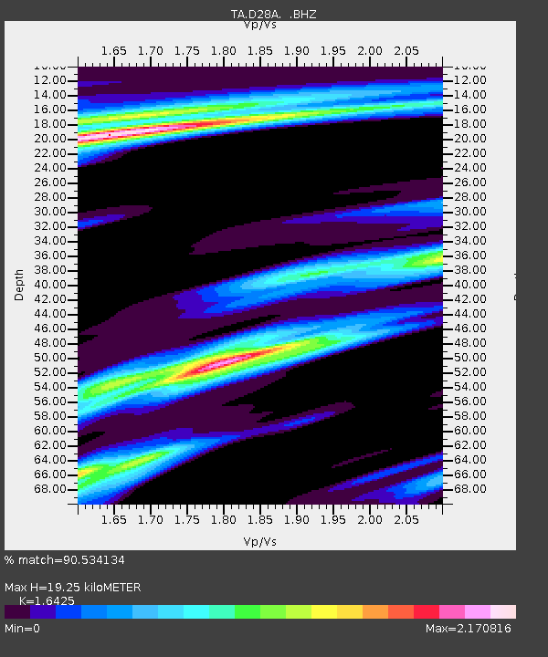
| Estimated Moho Depth: |
19.25 km |
| Estimated Crust Vp/Vs: |
1.64 |
| Assumed Crust Vp: |
6.438 km/s |
| Estimated Crust Vs: |
3.919 km/s |
| Estimated Crust Poisson's Ratio: |
0.21 |
|
| Radial Match: |
90.534134 % |
| Radial Bump: |
398 |
| Transverse Match: |
69.30487 % |
| Transverse Bump: |
400 |
| SOD ConfigId: |
2622 |
| Insert Time: |
2010-03-07 06:17:16.176 +0000 |
| GWidth: |
2.5 |
| Max Bumps: |
400 |
| Tol: |
0.001 |
|

Signal To Noise
| Channel | StoN | STA | LTA |
| TA:D28A: :BHZ:20090820T06:43:21.975013Z | 9.834335 | 1.301857E-6 | 1.3237874E-7 |
| TA:D28A: :BHN:20090820T06:43:21.975013Z | 3.4234498 | 6.872343E-7 | 2.0074322E-7 |
| TA:D28A: :BHE:20090820T06:43:21.975013Z | 0.7195707 | 2.1658512E-7 | 3.0099213E-7 |
| Arrivals |
| Ps | 2.0 SECOND |
| PpPs | 7.4 SECOND |
| PsPs/PpSs | 9.5 SECOND |


