You are here: Home > Network List > TS - TERRAscope (Southern California Seismic Network) Stations List
> Station PAS Pasadena, California, USA > Earthquake Result Viewer
PAS Pasadena, California, USA - Earthquake Result Viewer
| Earthquake location: |
Bonin Islands, Japan Region |
| Earthquake latitude/longitude: |
28.9/139.3 |
| Earthquake time(UTC): |
1998/08/20 (232) 06:40:55 GMT |
| Earthquake Depth: |
441 km |
| Earthquake Magnitude: |
6.1 MB, 7.0 UNKNOWN, 7.0 MW |
| Earthquake Catalog/Contributor: |
WHDF/NEIC |
|
| Network: |
TS TERRAscope (Southern California Seismic Network) |
| Station: |
PAS Pasadena, California, USA |
| Lat/Lon: |
34.15 N/118.17 W |
| Elevation: |
295 m |
|
| Distance: |
83.6 deg |
| Az: |
54.564 deg |
| Baz: |
300.552 deg |
| Ray Param: |
0.04486357 |
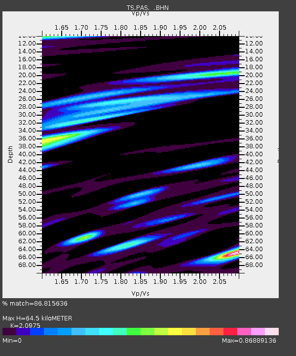
| Estimated Moho Depth: |
64.5 km |
| Estimated Crust Vp/Vs: |
2.10 |
| Assumed Crust Vp: |
6.1 km/s |
| Estimated Crust Vs: |
2.908 km/s |
| Estimated Crust Poisson's Ratio: |
0.35 |
|
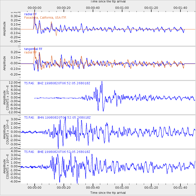
| Radial Match: |
86.815636 % |
| Radial Bump: |
400 |
| Transverse Match: |
88.23563 % |
| Transverse Bump: |
400 |
| SOD ConfigId: |
9875 |
| Insert Time: |
2010-02-26 14:36:56.880 +0000 |
| GWidth: |
2.5 |
| Max Bumps: |
400 |
| Tol: |
0.001 |
|
Signal To Noise
| Channel | StoN | STA | LTA |
| TS:PAS: :BHN:19980820T06:52:05.268018Z | 1.1730517 | 1.07785674E-7 | 9.188485E-8 |
| TS:PAS: :BHE:19980820T06:52:05.268018Z | 1.3553613 | 1.5634092E-7 | 1.1535E-7 |
| TS:PAS: :BHZ:19980820T06:52:05.268018Z | 3.9753425 | 4.7175416E-7 | 1.18670066E-7 |
| Arrivals |
| Ps | 12 SECOND |
| PpPs | 32 SECOND |
| PsPs/PpSs | 44 SECOND |


