You are here: Home > Network List > TA - USArray Transportable Network (new EarthScope stations) Stations List
> Station C28A Hausauer Farms, Kief, ND, USA > Earthquake Result Viewer
C28A Hausauer Farms, Kief, ND, USA - Earthquake Result Viewer

| Earthquake location: |
Near Coast Of Venezuela |
| Earthquake latitude/longitude: |
10.7/-67.9 |
| Earthquake time(UTC): |
2009/09/12 (255) 20:06:24 GMT |
| Earthquake Depth: |
10 km |
| Earthquake Magnitude: |
6.3 MB, 6.4 MS, 6.3 MW, 6.3 MW |
| Earthquake Catalog/Contributor: |
WHDF/NEIC |
|
| Network: |
TA USArray Transportable Network (new EarthScope stations) |
| Station: |
C28A Hausauer Farms, Kief, ND, USA |
| Lat/Lon: |
47.72 N/100.39 W |
| Elevation: |
524 m |
|
| Distance: |
45.9 deg |
| Az: |
329.676 deg |
| Baz: |
132.707 deg |
| Ray Param: |
0.070985176 |
| Estimated Moho Depth: |
30.75 km |
| Estimated Crust Vp/Vs: |
2.05 |
| Assumed Crust Vp: |
6.438 km/s |
| Estimated Crust Vs: |
3.14 km/s |
| Estimated Crust Poisson's Ratio: |
0.34 |
|
| Radial Match: |
93.95426 % |
| Radial Bump: |
304 |
| Transverse Match: |
81.50159 % |
| Transverse Bump: |
400 |
| SOD ConfigId: |
2622 |
| Insert Time: |
2010-03-07 06:17:42.218 +0000 |
| GWidth: |
2.5 |
| Max Bumps: |
400 |
| Tol: |
0.001 |
|
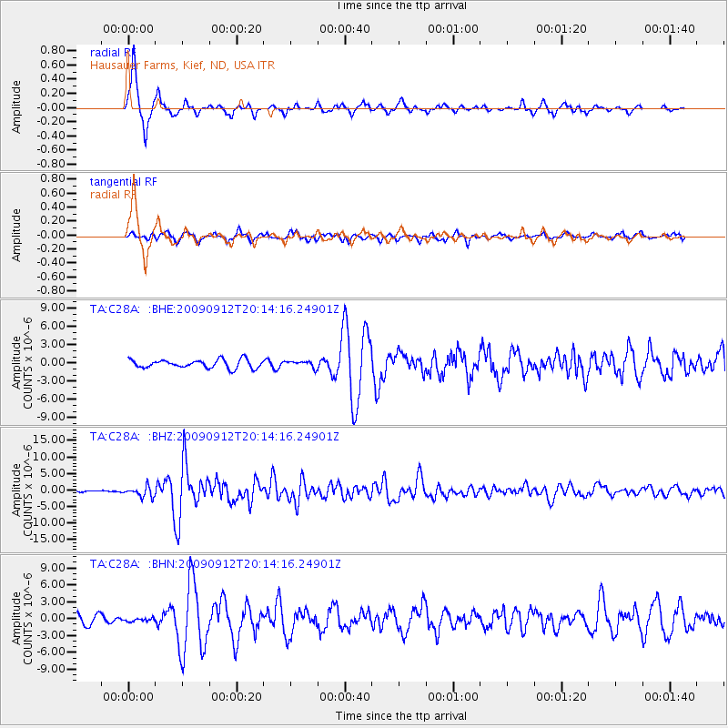
Signal To Noise
| Channel | StoN | STA | LTA |
| TA:C28A: :BHZ:20090912T20:14:16.24901Z | 6.84853 | 1.541112E-6 | 2.2502815E-7 |
| TA:C28A: :BHN:20090912T20:14:16.24901Z | 0.3847957 | 2.7830004E-7 | 7.2324104E-7 |
| TA:C28A: :BHE:20090912T20:14:16.24901Z | 0.77032435 | 5.2880836E-7 | 6.8647495E-7 |
| Arrivals |
| Ps | 5.3 SECOND |
| PpPs | 14 SECOND |
| PsPs/PpSs | 19 SECOND |


