You are here: Home > Network List > TA - USArray Transportable Network (new EarthScope stations) Stations List
> Station C28A Hausauer Farms, Kief, ND, USA > Earthquake Result Viewer
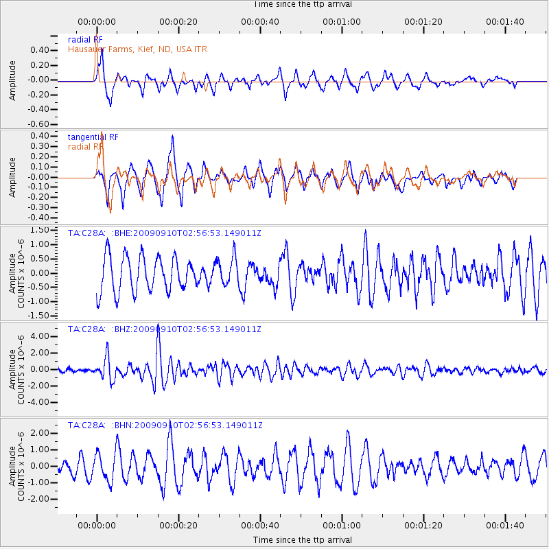
C28A Hausauer Farms, Kief, ND, USA - Earthquake Result Viewer
*The percent match for this event was below the threshold and hence no stack was calculated.
| Earthquake location: |
Kuril Islands |
| Earthquake latitude/longitude: |
48.3/154.2 |
| Earthquake time(UTC): |
2009/09/10 (253) 02:46:50 GMT |
| Earthquake Depth: |
36 km |
| Earthquake Magnitude: |
6.0 MB, 5.5 MS, 6.0 MW, 5.8 MW |
| Earthquake Catalog/Contributor: |
WHDF/NEIC |
|
| Network: |
TA USArray Transportable Network (new EarthScope stations) |
| Station: |
C28A Hausauer Farms, Kief, ND, USA |
| Lat/Lon: |
47.72 N/100.39 W |
| Elevation: |
524 m |
|
| Distance: |
64.6 deg |
| Az: |
46.119 deg |
| Baz: |
314.563 deg |
| Ray Param: |
$rayparam |
*The percent match for this event was below the threshold and hence was not used in the summary stack. |
|
| Radial Match: |
58.93649 % |
| Radial Bump: |
377 |
| Transverse Match: |
72.39981 % |
| Transverse Bump: |
400 |
| SOD ConfigId: |
2622 |
| Insert Time: |
2010-03-07 06:17:49.117 +0000 |
| GWidth: |
2.5 |
| Max Bumps: |
400 |
| Tol: |
0.001 |
|
Signal To Noise
| Channel | StoN | STA | LTA |
| TA:C28A: :BHZ:20090910T02:56:53.149011Z | 10.354194 | 1.3620048E-6 | 1.3154137E-7 |
| TA:C28A: :BHN:20090910T02:56:53.149011Z | 2.7469313 | 8.525709E-7 | 3.1037212E-7 |
| TA:C28A: :BHE:20090910T02:56:53.149011Z | 0.79770875 | 4.8447606E-7 | 6.0733447E-7 |
| Arrivals |
| Ps | |
| PpPs | |
| PsPs/PpSs | |


