You are here: Home > Network List > TS - TERRAscope (Southern California Seismic Network) Stations List
> Station PAS Pasadena, California, USA > Earthquake Result Viewer
PAS Pasadena, California, USA - Earthquake Result Viewer

| Earthquake location: |
Peru-Brazil Border Region |
| Earthquake latitude/longitude: |
-8.1/-74.2 |
| Earthquake time(UTC): |
1998/04/03 (093) 22:01:48 GMT |
| Earthquake Depth: |
165 km |
| Earthquake Magnitude: |
6.1 MB, 5.6 MS, 6.6 UNKNOWN, 6.6 MW |
| Earthquake Catalog/Contributor: |
WHDF/NEIC |
|
| Network: |
TS TERRAscope (Southern California Seismic Network) |
| Station: |
PAS Pasadena, California, USA |
| Lat/Lon: |
34.15 N/118.17 W |
| Elevation: |
295 m |
|
| Distance: |
59.2 deg |
| Az: |
317.921 deg |
| Baz: |
126.868 deg |
| Ray Param: |
0.06184944 |
| Estimated Moho Depth: |
30.5 km |
| Estimated Crust Vp/Vs: |
1.71 |
| Assumed Crust Vp: |
6.1 km/s |
| Estimated Crust Vs: |
3.572 km/s |
| Estimated Crust Poisson's Ratio: |
0.24 |
|
| Radial Match: |
89.72755 % |
| Radial Bump: |
387 |
| Transverse Match: |
82.37824 % |
| Transverse Bump: |
400 |
| SOD ConfigId: |
9875 |
| Insert Time: |
2010-02-26 14:37:04.730 +0000 |
| GWidth: |
2.5 |
| Max Bumps: |
400 |
| Tol: |
0.001 |
|
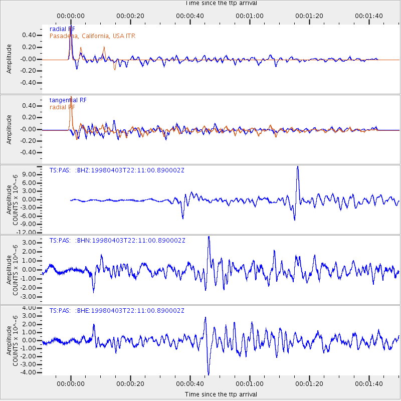
Signal To Noise
| Channel | StoN | STA | LTA |
| TS:PAS: :BHN:19980403T22:11:00.890002Z | 0.44505423 | 1.2654985E-7 | 2.84347E-7 |
| TS:PAS: :BHE:19980403T22:11:00.890002Z | 1.3640453 | 2.6188644E-7 | 1.919925E-7 |
| TS:PAS: :BHZ:19980403T22:11:00.890002Z | 2.5338259 | 5.0099334E-7 | 1.977221E-7 |
| Arrivals |
| Ps | 3.7 SECOND |
| PpPs | 13 SECOND |
| PsPs/PpSs | 17 SECOND |


