You are here: Home > Network List > TA - USArray Transportable Network (new EarthScope stations) Stations List
> Station C30A Mose, Pekin, ND, USA > Earthquake Result Viewer
C30A Mose, Pekin, ND, USA - Earthquake Result Viewer
| Earthquake location: |
Fox Islands, Aleutian Islands |
| Earthquake latitude/longitude: |
52.8/-167.0 |
| Earthquake time(UTC): |
2009/10/13 (286) 05:37:23 GMT |
| Earthquake Depth: |
24 km |
| Earthquake Magnitude: |
6.0 MB, 6.1 MS, 6.5 MW, 6.5 MW |
| Earthquake Catalog/Contributor: |
WHDF/NEIC |
|
| Network: |
TA USArray Transportable Network (new EarthScope stations) |
| Station: |
C30A Mose, Pekin, ND, USA |
| Lat/Lon: |
47.70 N/98.48 W |
| Elevation: |
480 m |
|
| Distance: |
42.6 deg |
| Az: |
68.169 deg |
| Baz: |
303.35 deg |
| Ray Param: |
0.07303391 |
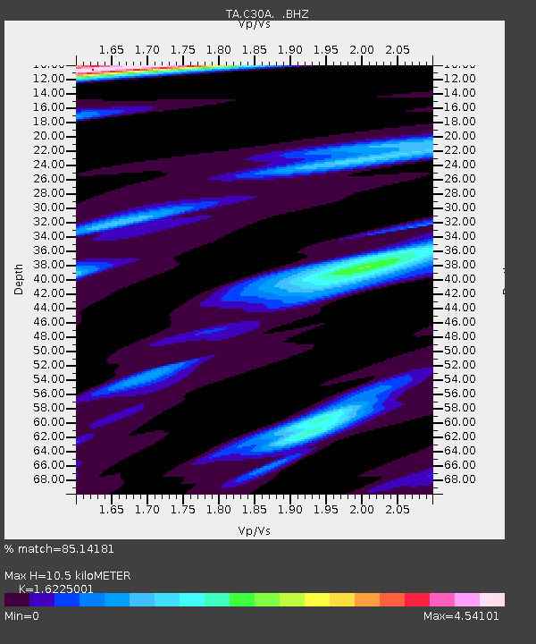
| Estimated Moho Depth: |
10.5 km |
| Estimated Crust Vp/Vs: |
1.62 |
| Assumed Crust Vp: |
6.53 km/s |
| Estimated Crust Vs: |
4.025 km/s |
| Estimated Crust Poisson's Ratio: |
0.19 |
|
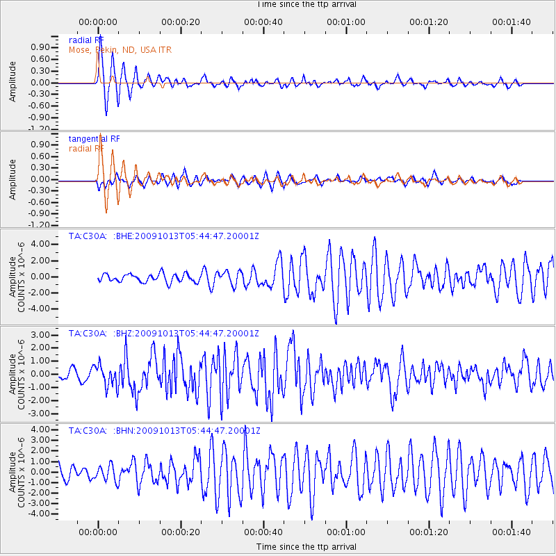
| Radial Match: |
85.14181 % |
| Radial Bump: |
327 |
| Transverse Match: |
69.1151 % |
| Transverse Bump: |
348 |
| SOD ConfigId: |
2622 |
| Insert Time: |
2010-03-07 06:18:31.017 +0000 |
| GWidth: |
2.5 |
| Max Bumps: |
400 |
| Tol: |
0.001 |
|
Signal To Noise
| Channel | StoN | STA | LTA |
| TA:C30A: :BHZ:20091013T05:44:47.20001Z | 3.0776317 | 8.196699E-7 | 2.6633137E-7 |
| TA:C30A: :BHN:20091013T05:44:47.20001Z | 1.014502 | 7.3940294E-7 | 7.2883336E-7 |
| TA:C30A: :BHE:20091013T05:44:47.20001Z | 1.6991036 | 8.4109536E-7 | 4.95023E-7 |
| Arrivals |
| Ps | 1.1 SECOND |
| PpPs | 3.9 SECOND |
| PsPs/PpSs | 5.0 SECOND |


