You are here: Home > Network List > US - United States National Seismic Network Stations List
> Station NEW Newport, Washington, USA > Earthquake Result Viewer
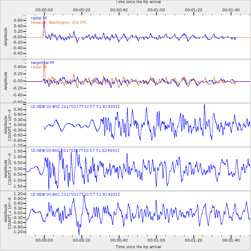
NEW Newport, Washington, USA - Earthquake Result Viewer
*The percent match for this event was below the threshold and hence no stack was calculated.
| Earthquake location: |
Near Islands, Aleutian Islands |
| Earthquake latitude/longitude: |
52.8/172.2 |
| Earthquake time(UTC): |
2017/03/27 (086) 10:50:19 GMT |
| Earthquake Depth: |
10 km |
| Earthquake Magnitude: |
6.1 Mww |
| Earthquake Catalog/Contributor: |
NEIC PDE/us |
|
| Network: |
US United States National Seismic Network |
| Station: |
NEW Newport, Washington, USA |
| Lat/Lon: |
48.26 N/117.12 W |
| Elevation: |
760 m |
|
| Distance: |
43.5 deg |
| Az: |
66.353 deg |
| Baz: |
303.652 deg |
| Ray Param: |
$rayparam |
*The percent match for this event was below the threshold and hence was not used in the summary stack. |
|
| Radial Match: |
66.995674 % |
| Radial Bump: |
400 |
| Transverse Match: |
55.71715 % |
| Transverse Bump: |
400 |
| SOD ConfigId: |
2028011 |
| Insert Time: |
2017-04-10 10:59:51.116 +0000 |
| GWidth: |
2.5 |
| Max Bumps: |
400 |
| Tol: |
0.001 |
|
Signal To Noise
| Channel | StoN | STA | LTA |
| US:NEW:00:BHZ:20170327T10:57:51.824993Z | 3.432056 | 6.7332826E-7 | 1.9618801E-7 |
| US:NEW:00:BH1:20170327T10:57:51.824993Z | 1.889704 | 3.6160344E-7 | 1.9135454E-7 |
| US:NEW:00:BH2:20170327T10:57:51.824993Z | 2.317081 | 2.9635456E-7 | 1.2789995E-7 |
| Arrivals |
| Ps | |
| PpPs | |
| PsPs/PpSs | |


