You are here: Home > Network List > TA - USArray Transportable Network (new EarthScope stations) Stations List
> Station D30A Buchanan, ND, USA > Earthquake Result Viewer
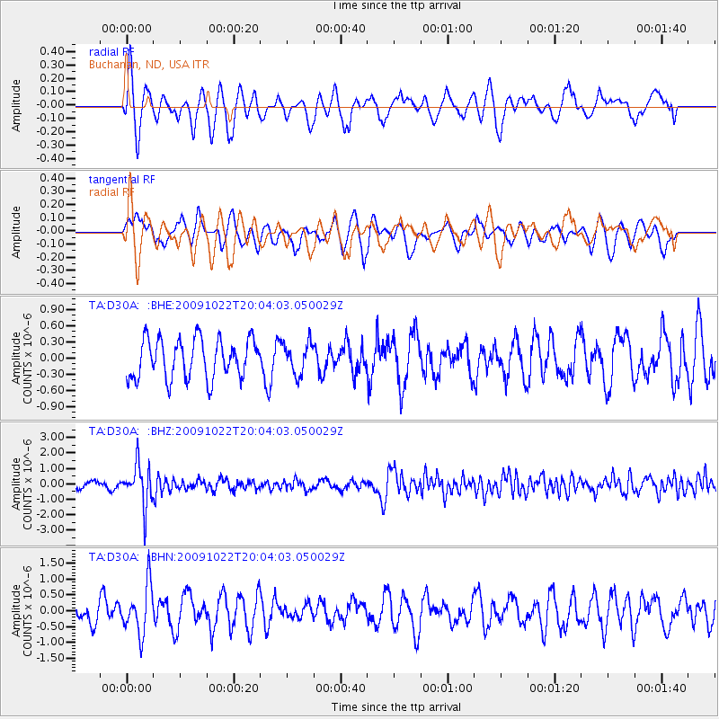
D30A Buchanan, ND, USA - Earthquake Result Viewer
*The percent match for this event was below the threshold and hence no stack was calculated.
| Earthquake location: |
Hindu Kush Region, Afghanistan |
| Earthquake latitude/longitude: |
36.5/70.9 |
| Earthquake time(UTC): |
2009/10/22 (295) 19:51:27 GMT |
| Earthquake Depth: |
186 km |
| Earthquake Magnitude: |
6.1 MB, 6.2 MW, 6.1 MW |
| Earthquake Catalog/Contributor: |
WHDF/NEIC |
|
| Network: |
TA USArray Transportable Network (new EarthScope stations) |
| Station: |
D30A Buchanan, ND, USA |
| Lat/Lon: |
47.11 N/98.76 W |
| Elevation: |
465 m |
|
| Distance: |
96.2 deg |
| Az: |
352.948 deg |
| Baz: |
8.325 deg |
| Ray Param: |
$rayparam |
*The percent match for this event was below the threshold and hence was not used in the summary stack. |
|
| Radial Match: |
66.444336 % |
| Radial Bump: |
400 |
| Transverse Match: |
65.200645 % |
| Transverse Bump: |
400 |
| SOD ConfigId: |
2622 |
| Insert Time: |
2010-03-07 06:19:10.536 +0000 |
| GWidth: |
2.5 |
| Max Bumps: |
400 |
| Tol: |
0.001 |
|
Signal To Noise
| Channel | StoN | STA | LTA |
| TA:D30A: :BHZ:20091022T20:04:03.050029Z | 5.215716 | 1.3521171E-6 | 2.5923904E-7 |
| TA:D30A: :BHN:20091022T20:04:03.050029Z | 2.4290252 | 7.72164E-7 | 3.178905E-7 |
| TA:D30A: :BHE:20091022T20:04:03.050029Z | 0.79951334 | 2.9291527E-7 | 3.6636698E-7 |
| Arrivals |
| Ps | |
| PpPs | |
| PsPs/PpSs | |


