You are here: Home > Network List > TA - USArray Transportable Network (new EarthScope stations) Stations List
> Station B30A Myrvik Farm, Edmore, ND, USA > Earthquake Result Viewer
B30A Myrvik Farm, Edmore, ND, USA - Earthquake Result Viewer
| Earthquake location: |
Norwegian Sea |
| Earthquake latitude/longitude: |
72.2/0.9 |
| Earthquake time(UTC): |
2009/08/20 (232) 06:35:04 GMT |
| Earthquake Depth: |
6.0 km |
| Earthquake Magnitude: |
5.9 MB, 5.7 MS, 6.0 MW, 6.0 MW |
| Earthquake Catalog/Contributor: |
WHDF/NEIC |
|
| Network: |
TA USArray Transportable Network (new EarthScope stations) |
| Station: |
B30A Myrvik Farm, Edmore, ND, USA |
| Lat/Lon: |
48.45 N/98.33 W |
| Elevation: |
480 m |
|
| Distance: |
47.4 deg |
| Az: |
296.777 deg |
| Baz: |
24.358 deg |
| Ray Param: |
0.07003248 |
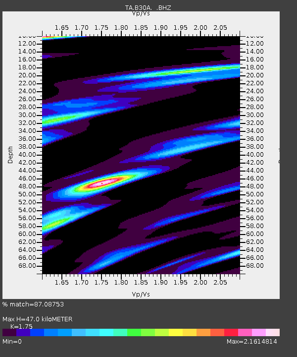
| Estimated Moho Depth: |
47.0 km |
| Estimated Crust Vp/Vs: |
1.75 |
| Assumed Crust Vp: |
6.53 km/s |
| Estimated Crust Vs: |
3.732 km/s |
| Estimated Crust Poisson's Ratio: |
0.26 |
|
| Radial Match: |
87.08753 % |
| Radial Bump: |
400 |
| Transverse Match: |
64.62034 % |
| Transverse Bump: |
400 |
| SOD ConfigId: |
2622 |
| Insert Time: |
2010-03-07 06:19:12.063 +0000 |
| GWidth: |
2.5 |
| Max Bumps: |
400 |
| Tol: |
0.001 |
|

Signal To Noise
| Channel | StoN | STA | LTA |
| TA:B30A: :BHZ:20090820T06:43:08.400001Z | 15.971447 | 1.2576885E-6 | 7.8746055E-8 |
| TA:B30A: :BHN:20090820T06:43:08.400001Z | 4.2236977 | 8.631168E-7 | 2.04351E-7 |
| TA:B30A: :BHE:20090820T06:43:08.400001Z | 1.6712915 | 3.1874282E-7 | 1.9071648E-7 |
| Arrivals |
| Ps | 5.8 SECOND |
| PpPs | 19 SECOND |
| PsPs/PpSs | 24 SECOND |


