You are here: Home > Network List > TA - USArray Transportable Network (new EarthScope stations) Stations List
> Station B18K Kokolik River, AK, USA > Earthquake Result Viewer
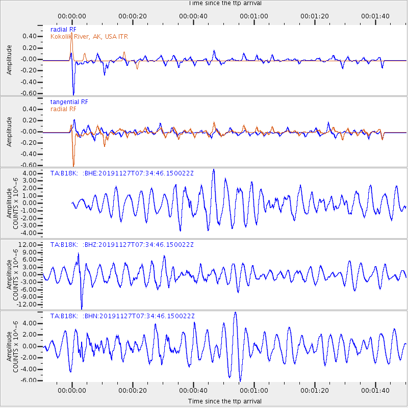
B18K Kokolik River, AK, USA - Earthquake Result Viewer
*The percent match for this event was below the threshold and hence no stack was calculated.
| Earthquake location: |
Crete, Greece |
| Earthquake latitude/longitude: |
35.7/23.3 |
| Earthquake time(UTC): |
2019/11/27 (331) 07:23:42 GMT |
| Earthquake Depth: |
72 km |
| Earthquake Magnitude: |
6.0 Mww |
| Earthquake Catalog/Contributor: |
NEIC PDE/us |
|
| Network: |
TA USArray Transportable Network (new EarthScope stations) |
| Station: |
B18K Kokolik River, AK, USA |
| Lat/Lon: |
69.36 N/161.80 W |
| Elevation: |
222 m |
|
| Distance: |
75.2 deg |
| Az: |
1.857 deg |
| Baz: |
355.735 deg |
| Ray Param: |
$rayparam |
*The percent match for this event was below the threshold and hence was not used in the summary stack. |
|
| Radial Match: |
53.941708 % |
| Radial Bump: |
400 |
| Transverse Match: |
70.661415 % |
| Transverse Bump: |
400 |
| SOD ConfigId: |
19951751 |
| Insert Time: |
2019-12-11 07:38:59.307 +0000 |
| GWidth: |
2.5 |
| Max Bumps: |
400 |
| Tol: |
0.001 |
|
Signal To Noise
| Channel | StoN | STA | LTA |
| TA:B18K: :BHZ:20191127T07:34:46.150022Z | 2.0714011 | 5.2083783E-6 | 2.5144227E-6 |
| TA:B18K: :BHN:20191127T07:34:46.150022Z | 1.1262054 | 2.2403212E-6 | 1.9892652E-6 |
| TA:B18K: :BHE:20191127T07:34:46.150022Z | 1.2026792 | 1.2898015E-6 | 1.0724402E-6 |
| Arrivals |
| Ps | |
| PpPs | |
| PsPs/PpSs | |


