You are here: Home > Network List > UU - University of Utah Regional Network Stations List
> Station CCUT Cedar City, UT, USA > Earthquake Result Viewer
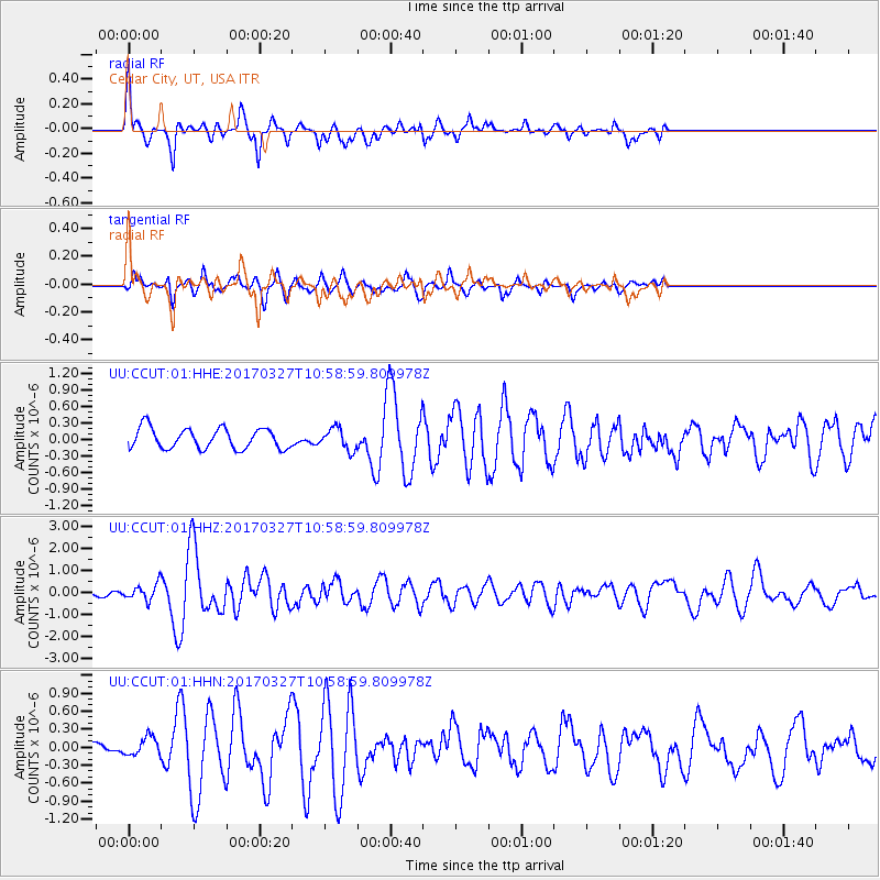
CCUT Cedar City, UT, USA - Earthquake Result Viewer
*The percent match for this event was below the threshold and hence no stack was calculated.
| Earthquake location: |
Near Islands, Aleutian Islands |
| Earthquake latitude/longitude: |
52.8/172.2 |
| Earthquake time(UTC): |
2017/03/27 (086) 10:50:19 GMT |
| Earthquake Depth: |
10 km |
| Earthquake Magnitude: |
6.1 Mww |
| Earthquake Catalog/Contributor: |
NEIC PDE/us |
|
| Network: |
UU University of Utah Regional Network |
| Station: |
CCUT Cedar City, UT, USA |
| Lat/Lon: |
37.55 N/113.36 W |
| Elevation: |
2127 m |
|
| Distance: |
52.3 deg |
| Az: |
75.425 deg |
| Baz: |
312.32 deg |
| Ray Param: |
$rayparam |
*The percent match for this event was below the threshold and hence was not used in the summary stack. |
|
| Radial Match: |
73.40402 % |
| Radial Bump: |
400 |
| Transverse Match: |
68.7335 % |
| Transverse Bump: |
363 |
| SOD ConfigId: |
2028011 |
| Insert Time: |
2017-04-10 11:00:19.257 +0000 |
| GWidth: |
2.5 |
| Max Bumps: |
400 |
| Tol: |
0.001 |
|
Signal To Noise
| Channel | StoN | STA | LTA |
| UU:CCUT:01:HHZ:20170327T10:58:59.809978Z | 2.851544 | 3.5385872E-7 | 1.2409373E-7 |
| UU:CCUT:01:HHN:20170327T10:58:59.809978Z | 1.1907947 | 1.6254357E-7 | 1.3650009E-7 |
| UU:CCUT:01:HHE:20170327T10:58:59.809978Z | 1.0527834 | 1.9692197E-7 | 1.870489E-7 |
| Arrivals |
| Ps | |
| PpPs | |
| PsPs/PpSs | |


