You are here: Home > Network List > TS - TERRAscope (Southern California Seismic Network) Stations List
> Station PAS Pasadena, California, USA > Earthquake Result Viewer
PAS Pasadena, California, USA - Earthquake Result Viewer
| Earthquake location: |
Fiji Islands Region |
| Earthquake latitude/longitude: |
-15.3/-178.6 |
| Earthquake time(UTC): |
2005/12/13 (347) 03:16:06 GMT |
| Earthquake Depth: |
10 km |
| Earthquake Magnitude: |
6.1 MB, 6.8 MS, 6.7 MW, 6.7 MW |
| Earthquake Catalog/Contributor: |
WHDF/NEIC |
|
| Network: |
TS TERRAscope (Southern California Seismic Network) |
| Station: |
PAS Pasadena, California, USA |
| Lat/Lon: |
34.15 N/118.17 W |
| Elevation: |
295 m |
|
| Distance: |
75.6 deg |
| Az: |
48.123 deg |
| Baz: |
240.058 deg |
| Ray Param: |
0.05157953 |
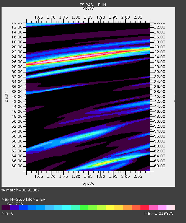
| Estimated Moho Depth: |
25.0 km |
| Estimated Crust Vp/Vs: |
1.73 |
| Assumed Crust Vp: |
6.1 km/s |
| Estimated Crust Vs: |
3.536 km/s |
| Estimated Crust Poisson's Ratio: |
0.25 |
|
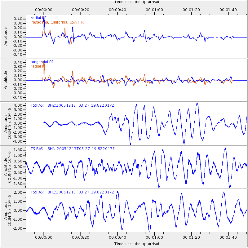
| Radial Match: |
88.91067 % |
| Radial Bump: |
400 |
| Transverse Match: |
72.00544 % |
| Transverse Bump: |
400 |
| SOD ConfigId: |
2564 |
| Insert Time: |
2010-02-26 14:37:09.162 +0000 |
| GWidth: |
2.5 |
| Max Bumps: |
400 |
| Tol: |
0.001 |
|
Signal To Noise
| Channel | StoN | STA | LTA |
| TS:PAS: :BHN:20051213T03:27:19.822017Z | 0.86961854 | 2.92857E-7 | 3.367649E-7 |
| TS:PAS: :BHE:20051213T03:27:19.822017Z | 1.9898458 | 5.7517707E-7 | 2.890561E-7 |
| TS:PAS: :BHZ:20051213T03:27:19.822017Z | 4.512303 | 1.2364399E-6 | 2.7401524E-7 |
| Arrivals |
| Ps | 3.1 SECOND |
| PpPs | 11 SECOND |
| PsPs/PpSs | 14 SECOND |


