You are here: Home > Network List > TA - USArray Transportable Network (new EarthScope stations) Stations List
> Station I30M Mount Dempster, Yukon, CAN > Earthquake Result Viewer
I30M Mount Dempster, Yukon, CAN - Earthquake Result Viewer
| Earthquake location: |
Crete, Greece |
| Earthquake latitude/longitude: |
35.7/23.3 |
| Earthquake time(UTC): |
2019/11/27 (331) 07:23:42 GMT |
| Earthquake Depth: |
72 km |
| Earthquake Magnitude: |
6.0 Mww |
| Earthquake Catalog/Contributor: |
NEIC PDE/us |
|
| Network: |
TA USArray Transportable Network (new EarthScope stations) |
| Station: |
I30M Mount Dempster, Yukon, CAN |
| Lat/Lon: |
65.22 N/136.38 W |
| Elevation: |
1399 m |
|
| Distance: |
78.1 deg |
| Az: |
351.385 deg |
| Baz: |
16.811 deg |
| Ray Param: |
0.049702235 |
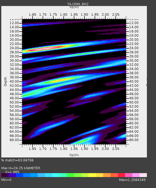
| Estimated Moho Depth: |
24.25 km |
| Estimated Crust Vp/Vs: |
1.70 |
| Assumed Crust Vp: |
6.566 km/s |
| Estimated Crust Vs: |
3.874 km/s |
| Estimated Crust Poisson's Ratio: |
0.23 |
|
| Radial Match: |
83.86786 % |
| Radial Bump: |
400 |
| Transverse Match: |
69.46208 % |
| Transverse Bump: |
400 |
| SOD ConfigId: |
19951751 |
| Insert Time: |
2019-12-11 07:39:40.485 +0000 |
| GWidth: |
2.5 |
| Max Bumps: |
400 |
| Tol: |
0.001 |
|
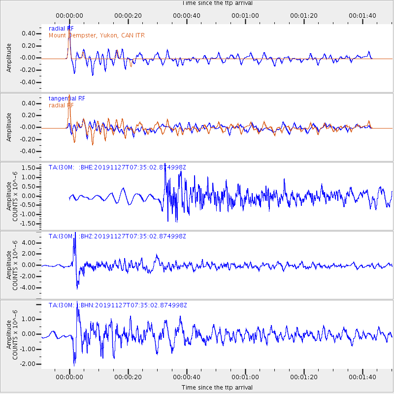
Signal To Noise
| Channel | StoN | STA | LTA |
| TA:I30M: :BHZ:20191127T07:35:02.874998Z | 13.986916 | 2.0968007E-6 | 1.4991159E-7 |
| TA:I30M: :BHN:20191127T07:35:02.874998Z | 6.182843 | 9.729431E-7 | 1.5736177E-7 |
| TA:I30M: :BHE:20191127T07:35:02.874998Z | 3.3939989 | 5.894325E-7 | 1.7366904E-7 |
| Arrivals |
| Ps | 2.7 SECOND |
| PpPs | 9.6 SECOND |
| PsPs/PpSs | 12 SECOND |


