You are here: Home > Network List > UU - University of Utah Regional Network Stations List
> Station VRUT Veyo Road, Veyo, UT, USA > Earthquake Result Viewer
VRUT Veyo Road, Veyo, UT, USA - Earthquake Result Viewer
| Earthquake location: |
Near Islands, Aleutian Islands |
| Earthquake latitude/longitude: |
52.8/172.2 |
| Earthquake time(UTC): |
2017/03/27 (086) 10:50:19 GMT |
| Earthquake Depth: |
10 km |
| Earthquake Magnitude: |
6.1 Mww |
| Earthquake Catalog/Contributor: |
NEIC PDE/us |
|
| Network: |
UU University of Utah Regional Network |
| Station: |
VRUT Veyo Road, Veyo, UT, USA |
| Lat/Lon: |
37.46 N/113.86 W |
| Elevation: |
1874 m |
|
| Distance: |
52.1 deg |
| Az: |
75.842 deg |
| Baz: |
312.277 deg |
| Ray Param: |
0.06700402 |
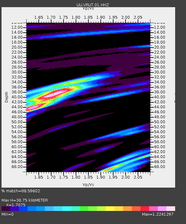
| Estimated Moho Depth: |
38.75 km |
| Estimated Crust Vp/Vs: |
1.71 |
| Assumed Crust Vp: |
6.194 km/s |
| Estimated Crust Vs: |
3.628 km/s |
| Estimated Crust Poisson's Ratio: |
0.24 |
|
| Radial Match: |
86.59602 % |
| Radial Bump: |
400 |
| Transverse Match: |
60.391994 % |
| Transverse Bump: |
400 |
| SOD ConfigId: |
2028011 |
| Insert Time: |
2017-04-10 11:00:51.161 +0000 |
| GWidth: |
2.5 |
| Max Bumps: |
400 |
| Tol: |
0.001 |
|

Signal To Noise
| Channel | StoN | STA | LTA |
| UU:VRUT:01:HHZ:20170327T10:58:58.100017Z | 4.542024 | 1.3172457E-8 | 2.9001292E-9 |
| UU:VRUT:01:HHN:20170327T10:58:58.100017Z | 1.0067537 | 3.3906205E-9 | 3.3678749E-9 |
| UU:VRUT:01:HHE:20170327T10:58:58.100017Z | 1.8780029 | 7.228602E-9 | 3.84909E-9 |
| Arrivals |
| Ps | 4.7 SECOND |
| PpPs | 16 SECOND |
| PsPs/PpSs | 21 SECOND |


