You are here: Home > Network List > C0 - Colorado Geological Survey Seismic Network Stations List
> Station BRIGG Briggsdale, Colorado, USA > Earthquake Result Viewer
BRIGG Briggsdale, Colorado, USA - Earthquake Result Viewer
| Earthquake location: |
Near Islands, Aleutian Islands |
| Earthquake latitude/longitude: |
52.8/172.2 |
| Earthquake time(UTC): |
2017/03/27 (086) 10:50:19 GMT |
| Earthquake Depth: |
10 km |
| Earthquake Magnitude: |
6.1 Mww |
| Earthquake Catalog/Contributor: |
NEIC PDE/us |
|
| Network: |
C0 Colorado Geological Survey Seismic Network |
| Station: |
BRIGG Briggsdale, Colorado, USA |
| Lat/Lon: |
40.58 N/104.32 W |
| Elevation: |
1479 m |
|
| Distance: |
55.4 deg |
| Az: |
66.772 deg |
| Baz: |
312.894 deg |
| Ray Param: |
0.06479646 |
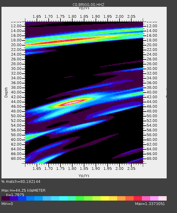
| Estimated Moho Depth: |
44.25 km |
| Estimated Crust Vp/Vs: |
1.80 |
| Assumed Crust Vp: |
6.306 km/s |
| Estimated Crust Vs: |
3.508 km/s |
| Estimated Crust Poisson's Ratio: |
0.28 |
|
| Radial Match: |
80.182144 % |
| Radial Bump: |
345 |
| Transverse Match: |
67.69279 % |
| Transverse Bump: |
352 |
| SOD ConfigId: |
2028011 |
| Insert Time: |
2017-04-10 11:01:25.928 +0000 |
| GWidth: |
2.5 |
| Max Bumps: |
400 |
| Tol: |
0.001 |
|

Signal To Noise
| Channel | StoN | STA | LTA |
| C0:BRIGG:00:HHZ:20170327T10:59:22.74998Z | 3.3145313 | 7.6965637E-7 | 2.3220669E-7 |
| C0:BRIGG:00:HHN:20170327T10:59:22.74998Z | 0.8530165 | 4.5171302E-7 | 5.295478E-7 |
| C0:BRIGG:00:HHE:20170327T10:59:22.74998Z | 0.80521494 | 3.7409447E-7 | 4.6458956E-7 |
| Arrivals |
| Ps | 5.9 SECOND |
| PpPs | 19 SECOND |
| PsPs/PpSs | 25 SECOND |


