You are here: Home > Network List > IU - Global Seismograph Network (GSN - IRIS/USGS) Stations List
> Station PMG Port Moresby, New Guinea > Earthquake Result Viewer
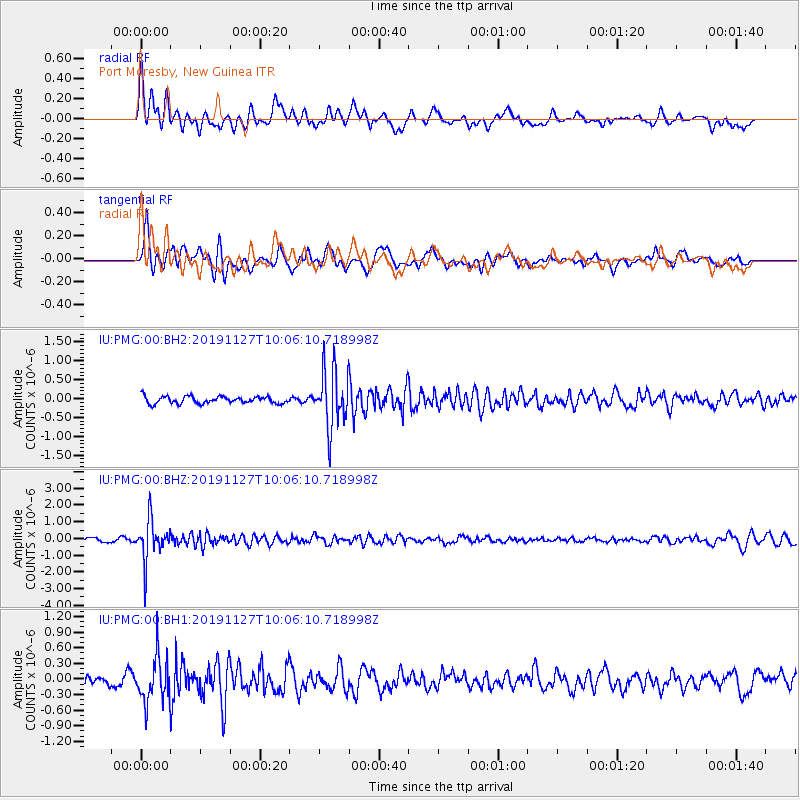
PMG Port Moresby, New Guinea - Earthquake Result Viewer
*The percent match for this event was below the threshold and hence no stack was calculated.
| Earthquake location: |
South Of Fiji Islands |
| Earthquake latitude/longitude: |
-22.1/-179.5 |
| Earthquake time(UTC): |
2019/11/27 (331) 10:00:40 GMT |
| Earthquake Depth: |
570 km |
| Earthquake Magnitude: |
5.6 Mww |
| Earthquake Catalog/Contributor: |
NEIC PDE/us |
|
| Network: |
IU Global Seismograph Network (GSN - IRIS/USGS) |
| Station: |
PMG Port Moresby, New Guinea |
| Lat/Lon: |
9.40 S/147.16 E |
| Elevation: |
90 m |
|
| Distance: |
34.4 deg |
| Az: |
286.237 deg |
| Baz: |
115.545 deg |
| Ray Param: |
$rayparam |
*The percent match for this event was below the threshold and hence was not used in the summary stack. |
|
| Radial Match: |
75.709946 % |
| Radial Bump: |
400 |
| Transverse Match: |
66.09973 % |
| Transverse Bump: |
400 |
| SOD ConfigId: |
19951751 |
| Insert Time: |
2019-12-11 10:12:04.205 +0000 |
| GWidth: |
2.5 |
| Max Bumps: |
400 |
| Tol: |
0.001 |
|
Signal To Noise
| Channel | StoN | STA | LTA |
| IU:PMG:00:BHZ:20191127T10:06:10.718998Z | 11.815348 | 1.1958847E-6 | 1.0121452E-7 |
| IU:PMG:00:BH1:20191127T10:06:10.718998Z | 4.535386 | 4.174223E-7 | 9.203678E-8 |
| IU:PMG:00:BH2:20191127T10:06:10.718998Z | 8.029681 | 7.467194E-7 | 9.29949E-8 |
| Arrivals |
| Ps | |
| PpPs | |
| PsPs/PpSs | |


