You are here: Home > Network List > TA - USArray Transportable Network (new EarthScope stations) Stations List
> Station D23K Nanushuk River, AK USA > Earthquake Result Viewer
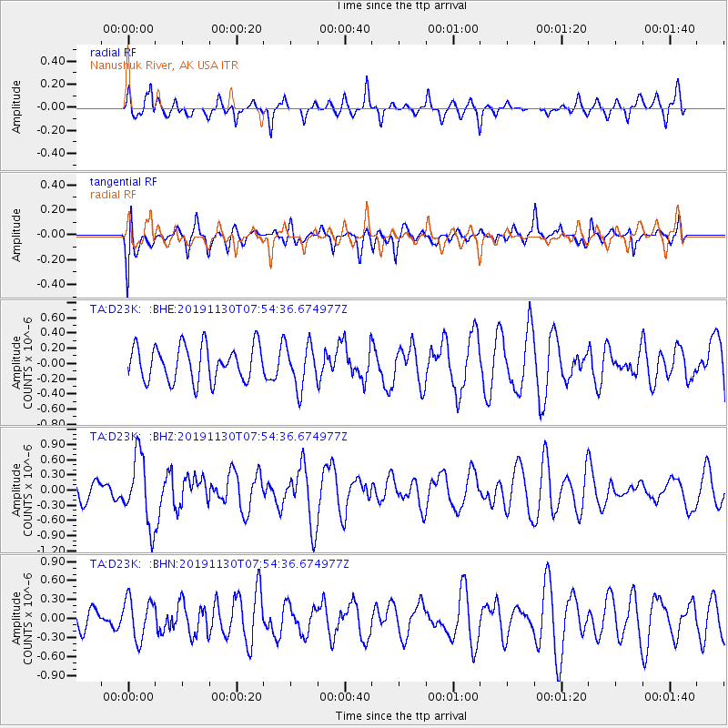
D23K Nanushuk River, AK USA - Earthquake Result Viewer
*The percent match for this event was below the threshold and hence no stack was calculated.
| Earthquake location: |
Near Coast Of Guatemala |
| Earthquake latitude/longitude: |
13.9/-91.9 |
| Earthquake time(UTC): |
2019/11/30 (334) 07:44:25 GMT |
| Earthquake Depth: |
48 km |
| Earthquake Magnitude: |
5.6 Mww |
| Earthquake Catalog/Contributor: |
NEIC PDE/us |
|
| Network: |
TA USArray Transportable Network (new EarthScope stations) |
| Station: |
D23K Nanushuk River, AK USA |
| Lat/Lon: |
68.97 N/150.68 W |
| Elevation: |
406 m |
|
| Distance: |
66.1 deg |
| Az: |
340.26 deg |
| Baz: |
114.718 deg |
| Ray Param: |
$rayparam |
*The percent match for this event was below the threshold and hence was not used in the summary stack. |
|
| Radial Match: |
61.739235 % |
| Radial Bump: |
373 |
| Transverse Match: |
44.41172 % |
| Transverse Bump: |
400 |
| SOD ConfigId: |
19951751 |
| Insert Time: |
2019-12-14 07:57:38.195 +0000 |
| GWidth: |
2.5 |
| Max Bumps: |
400 |
| Tol: |
0.001 |
|
Signal To Noise
| Channel | StoN | STA | LTA |
| TA:D23K: :BHZ:20191130T07:54:36.674977Z | 3.0134776 | 6.834305E-7 | 2.2679131E-7 |
| TA:D23K: :BHN:20191130T07:54:36.674977Z | 1.6442767 | 3.2542536E-7 | 1.9791399E-7 |
| TA:D23K: :BHE:20191130T07:54:36.674977Z | 1.2304381 | 2.8059011E-7 | 2.2804082E-7 |
| Arrivals |
| Ps | |
| PpPs | |
| PsPs/PpSs | |


