You are here: Home > Network List > US - United States National Seismic Network Stations List
> Station HAWA Hanford, Washington, USA > Earthquake Result Viewer
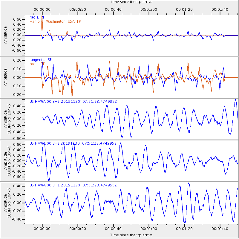
HAWA Hanford, Washington, USA - Earthquake Result Viewer
*The percent match for this event was below the threshold and hence no stack was calculated.
| Earthquake location: |
Near Coast Of Guatemala |
| Earthquake latitude/longitude: |
13.9/-91.9 |
| Earthquake time(UTC): |
2019/11/30 (334) 07:44:25 GMT |
| Earthquake Depth: |
48 km |
| Earthquake Magnitude: |
5.6 Mww |
| Earthquake Catalog/Contributor: |
NEIC PDE/us |
|
| Network: |
US United States National Seismic Network |
| Station: |
HAWA Hanford, Washington, USA |
| Lat/Lon: |
46.39 N/119.53 W |
| Elevation: |
364 m |
|
| Distance: |
39.8 deg |
| Az: |
329.884 deg |
| Baz: |
135.261 deg |
| Ray Param: |
$rayparam |
*The percent match for this event was below the threshold and hence was not used in the summary stack. |
|
| Radial Match: |
57.5421 % |
| Radial Bump: |
365 |
| Transverse Match: |
67.21079 % |
| Transverse Bump: |
282 |
| SOD ConfigId: |
19951751 |
| Insert Time: |
2019-12-14 07:58:23.534 +0000 |
| GWidth: |
2.5 |
| Max Bumps: |
400 |
| Tol: |
0.001 |
|
Signal To Noise
| Channel | StoN | STA | LTA |
| US:HAWA:00:BHZ:20191130T07:51:23.474995Z | 1.6373432 | 4.77145E-7 | 2.9141418E-7 |
| US:HAWA:00:BH1:20191130T07:51:23.474995Z | 1.0119146 | 1.2085655E-7 | 1.1943355E-7 |
| US:HAWA:00:BH2:20191130T07:51:23.474995Z | 1.9353948 | 2.179632E-7 | 1.1261951E-7 |
| Arrivals |
| Ps | |
| PpPs | |
| PsPs/PpSs | |


